The oil and gas industry is one of the most critical industries that fuels progress, development, and basic human needs. Being a key part of the global economy, it has one of the largest capital investments, as well as revenues. Needless to say, just like any other industry, it has been highly impacted by various software solutions aimed to optimize, automate and enhance the most critical processes across many businesses.
According to Markets and Markets, the global oil and gas cloud applications market size is expected to reach $9.4 billion by 2024. Among the cultivated technologies, a large share of investments is allocated to GIS oil and gas solutions.
With over 6 years of experience in GIS software development, Mappitall knows how to create solutions that transform various industries. Thus, in this article we’ll share our knowledge on the importance of GIS in the oil and gas industry, its fields of use, and the benefits of its application. In case you are looking for a partner who’d implement GIS software into your oil and gas business, make sure to check our portfolio and contact us to discuss the details of cooperation.
Who Uses GIS Software in Oil Industry and Gas Field?
Today, GIS solutions deliver a clear business benefit across various oil and gas companies. Regardless of the company’s field focus, they provide multiple opportunities for complex data capturing, processing, and storage, field teams’ remote management, real-time pipeline/site updates, resource site mapping, and many more.
Because of these lucrative benefits, oil and gas GIS mapping is mainly used in the following fields:
Tech departments of oil and gas companies
Accounting departments of oil and gas companies
Oil and gas exploration companies
Pipeline construction, routing, and maintenance companies
Environmental monitoring and protection companies
Emergency response companies
These are only some of the enterprises that have been actively using GIS software across different sectors of the oil and gas industry. Nevertheless, this technology is applied to almost every step of the oil and gas process: from well planning to refinery management and emergency response, to better environmental monitoring.
With this said, let’s now explore the concrete benefits of applying GIS solutions to diverse fields of the oil and gas industry.
GIS software for oil and gas can enhance a company’s performance through increased efficiencies in workflow, forecasting, and resource allocation, as well as advanced risk mitigation across different fields of use.
However, just like with many other technologies, the key potential of GIS mapping within the target industry is mainly evaluated through the concrete advantages it features for various oil and gas enterprises. Below, we have covered the most notable benefits of GIS analytics software for oil industry with a detailed overview of their efficiency within each option specifically:
Empowers decision-making – GIS maps can significantly optimize the company’s workflow by providing an accurate oil and gas data analysis. In turn, the company’s departments can use this information to make more profitable data-driven decisions.
Supports future action and ongoing exploration activities – GIS solutions are also widely used in forecasting, as it integrates unrelated data to help organizations better understand spatial patterns and relationships in long-term perspectives.
Increased efficiencies – With GIS in oil and gas, the key processes are performed within a shorter time and for less cost. So, companies apply GIS maps for source spotting, well planning, refinery management, emergency response, and many other processes that include any sort of geo data.
Cost-saving and time-efficiency – While improving any data-driven processes, oil and gas companies also get a huge win in cost optimization as well. Employees are no longer required to spend hours for manual analysis and can get the information they need in real-time within a few clicks. Moreover, custom GIS solutions enable optimizing the time for task completion, which improves the company’s performance and income.
Seamless management – Whether you’re using GIS in oil exploration, pipeline routing, or asset management, this technology can greatly streamline and automate complex, time-consuming processes (data analysis, comparison, etc). Thus, your employees get more time for other critical aspects such as forecasting and planning.
Improved communication – With GIS services, employees no longer need to share the updated files via email, as it’s 24/7 available in a single app. Apart from the mapping solutions, this software can include asset management systems, chatting and commenting options, as well as many other useful features which can enhance employee interaction and boost productivity.
Record keeping – the GIS maps are usually stored in the cloud, which means the eligible workers can access the required data anytime and from nearly anywhere. At the same time, it allows for conducting of historical analysis and data comparison, which is one of the most essential aspects of the oil and gas industry.
As you can see, there are many advantages of GIS development for the oil and gas industry. It’s quite obvious, that having realized the potential of this technology, the next question business owners ask is what are the concrete uses of GIS oil and gas software. Keep on reading to get this uncovered!
How to Use GIS Solutions in The Oil and Gas Industry
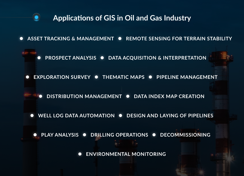
Describe the use of GIS in this area. The title of each application should be an H3 subtitle. Consider at least 15 types of application of GIS in oil and gas industry. List of examples below.
Asset Tracking & Management
GIS in oil and gas can store, categorize and specify the location of each asset: pipelines, wells, pump stations, and tank terminals. Moreover, the feature of non-spatial data monitoring allows for conducting assets’ timely maintenance and repair.
Remote Sensing for Terrain Stability
GIS in the oil industry also features the potential geohazards monitoring and predictions. Based on the InSAR information, companies can evaluate the risks and decide where and when to deploy staff, how to enhance safety, and ensure uninterrupted operation.
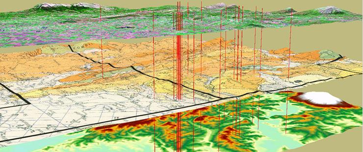
Prospect Analysis
GIS solutions are actively applied to estimate the resource reserves or volumes. It is performed through the raster analysis and spatial analysis of reservoir capacities, or well data from shale sources.
Data Acquisition & Interpretation
With GIS, you can acquire data for seismic, gravity, magnetic, and tomographic visualization and interpretation. In turn, this can be used for complex process planning, (drilling, extraction, transportation, etc), 3D projections, surface mapping, forecasting, and many more.
Exploration Survey
In onshore surveys, GIS allows the creation of a visual framework to explore all the assets available. For offshore, it contributes to bathymetry mapping and seafloor surveys, shipping lane maps, and other activities.
Thematic Maps
With GIS in oil and gas, businesses can create mapping resources that are utilized by different departments and for a diverse range of purposes. Thus, you can represent the required information in colors, such as density, percent, average value, or quantity of an event within a geographic area.
Pipeline Management
GIS is also used to track and analyze the spatially dispersed data in real-time remotely. It is applied to access the seafloor geodesy and asset management data offshore, which enables monitoring pipelines for geohazards and leaks.
Distribution Management
Another one GIS application in the oil and gas industry. Pipeline routing and management in GIS are also used for the effective planning and tracking of petroleum distribution. Companies can now visualize the most cost and time-effective routing options from well to refinery to selling to the end customer.
With GIS in oil and gas, companies can deliver complex data analysis and prediction scenarios in a fast and convenient way to see real-time situations. This notably reduces the time spent on information search, comparison, and analysis, as well as other workflow aspects.
Well Log Data Automation
Getting all the well-log data tracked within a single software can significantly streamline the entire business workflow. Companies no longer need to track the paper logs and every employee can access the up-to-date information whenever they need it. Additionally, it speeds up documentation handling and updates, which decreases the potential for errors.
Design and Laying of Pipelines
GIS solutions enable efficient planning of the optimal paths of pipeline network construction, which are environmentally friendly and cost-efficient. According to MDPI, the GIS capabilities can reduce up to 20% of costs by modeling the lowest cost path for pipeline system construction.
Play Analysis
This GIS aspect allows for mitigation of various risk segments through detailed mapping and playable elements. Thus, companies can conduct ground truthing or develop validating imagery based on field survey data.
Drilling Operations
Probably one of the most valuable features of GIS in oil and gas is its ability to empower decision-making for efficient and productive drilling operations. For instance, you can analyze the surface location, determine the type of rig, and acquire log data remotely, which are aimed at optimizing the drilling patterns and configurations.
Decommissioning
GIS data can be also applied in the oil industry during the decommissioning process: it can compare the target field data to earlier oil field life cycle phases to define the best time to remove the infrastructure and assets placed. This ensures an effective site and land recovery without any damage to the environment and the company’s profits.
Environmental Monitoring
With more and more environmental regulations implemented, it becomes critical for the oil and gas industry to follow the rules set, as well as quickly respond to any identified problems that violate those. GIS allows companies to effectively track the environmental data and resolve the issues, which reduces the cost loss and maintains the land potential once drilling and distribution are complete.
Who Can Help Develop and Deploy GIS Software for Oil and Gas Companies?
Though the demand for GIS oil and gas solutions emerged comparatively recently, so far software providers have created many tools to serve the companies’ basic needs. Mapping platforms have opened up a wide range of opportunities for automation, optimization, and increased workflow efficiency, so the ready-made solutions became highly popular among businesses of different industry focuses.
The biggest drawback of these solutions is that they usually cannot meet the company’s changing needs in full. With this in mind, in most cases, business owners have several options to choose from:
Give up on automating less critical processes, or conduct the data analysis manually, which hits the productivity and increases the employee cost
Consider using multiple systems from different providers which increases the company’s expenses
Invest in a custom GIS software for the oil and gas industry designed to fit the current company’s goals, requirements, and needs, which can optimize resource allocation, benefit process automation, and enhance the overall performance as well
The last option seems more lucrative for oil and gas companies, but not all those actually apply it in practice. Developing a custom GIS solution requires more investments rather than using the ready-made solution, which makes it less popular among oil and gas companies.
However, GIS and oil and gas companies can win a lot from a long-term perspective, mainly in profitability and competitiveness. Rather than splitting the processes between the ready-made tools, they create a single, versatile custom solution that ideally meets all the business objectives.
Fortunately, there are various development vendors such as Mappitall, which possess deep expertise in GIS development and consulting services. Regardless of your goals, they’re ready to create a custom solution for any oil and gas business!
Entrust GIS Development for Oil and Gas Industry to Mappitall!
For over 15 years, Mappitall has been one of the most reputable GIS mapping partners for various companies across the globe. So far our team has successfully implemented nearly 90 projects, and there are dozens of solutions still in progress.
Mappitall features experienced, dedicated GIS developers with middle to senior ranks, that keep an eye on the latest trends across different industries. That is why, in our portfolio you can find various cases from agriculture, transportation, navigation, real estate, and other industries, offering innovative, efficient solutions aimed to optimize business performance.
Regardless of the project’s complexity and industry focus, we’re ready to meet even the most challenging cases to deliver the high-end GIS solution for your oil and gas business. Are you considering a project in custom GIS software development? Request a quote from Mappitall’s best experts and discover ways to improve your business performance today!
Final Thoughts
Oil and gas GIS data processing tools open up a wide range of perspectives for the target industry. So, for more and more businesses within the target industry, GIS application is not an optional trend but rather a must-have solution that can boost their performance as well as add to their competitiveness.
There are diverse options of using GIS software in the oil industry, which are applied across different fields. From oil and gas extraction and transportation to the forecasting and tangential scopes (environment, risk assessments, etc). Nevertheless, regardless of the use scope, any business can benefit in costs, time, and performance efficiency.
Mappitall experts have deep knowledge of first-class GIS technologies across various industries and how they can help to improve nearly any business performance today. In particular, our team has been thoroughly learning the potential of GIS in the oil and gas field for years and is now ready to come up with the most effective software solutions that specifically target your enterprise.
If you have any questions concerning the GIS software in the oil and gas industry or are ready to get your project started right away – feel free to contact us! Mappitall’s best GIS experts are always here to assist in creating the most effective strategy for your custom GIS oil and gas project!
Frequently Asked Questions
Discover the most typical questions concerning GIS in oil and gas industry to learn deeper about how this technology can benefit your business today!
How is GIS used in oil and gas industry?
Oil and gas GIS mapping enables industry-related data capturing, analysis and storage that is applied across a diverse range of processes, from location and extraction to fieldwork management and resource transportation. For instance, it can help to effectively locate the pipelines, manage field teams remotely, conduct analysis of exploratory wells and receive up-to-date insights about the site or pipeline status.
How is GIS helping to improve gas company growth?
With the functional GIS oil and gas solutions implemented, companies can get an accurate mapping and spatial analysis of the critical data. Within the target industry, GIS can significantly enhance operational efficiency across different oil and gas extraction processes, transportation, and distribution, making them more time-optimized and cost-efficient.
Can GIS developers make an oil spill control solution?
Yes, GIS specialists can help you to develop an efficient mapping software for oil spill control that complies with the key data from various resources, such as nautical maps, geodatabases, ground truth, and remote sensing data. This solution enables the key information, including predictions of oil spill sites, assessing the intensity of oil pollution, well planning, pipeline monitoring, and many more.
How much will it cost to develop a GIS solution for an oil and gas company?
The overall costs required to develop a functional GIS software used in oil and gas are usually calculated individually for each project. As a rule, it mainly depends on the project’s complexity, the number of developers involved, and the desired functionality you want to get as a result. So, it’s recommended to request a consultation from your GIS software vendor to get accurate project estimates specifically for your business.
Get in touch with us
Want to discuss your project?
Use our expertise to design your custom mapping software solution.
Just contact us:
Tell us about your project goals, and we’ll get back to you in no time!
An entrepreneur and business leader, Volodymyr began his career in the late 1990s at the Laboratory of Geoinformation Systems of the Kharkiv National University of Radioelectronics.
In 2007 Volodymyr created Mappitall, and grew the company from a small agency providing GIS solutions to one of the industry leaders in Ukraine, a reliable technology partner for many international enterprises and top-level organizations around the world.
As CEO, Volodymyr is the driving force behind the company’s strategy and business development, actively working on the development of Mappitall’s business model, attracting more and more talented people who share his vision and mission.