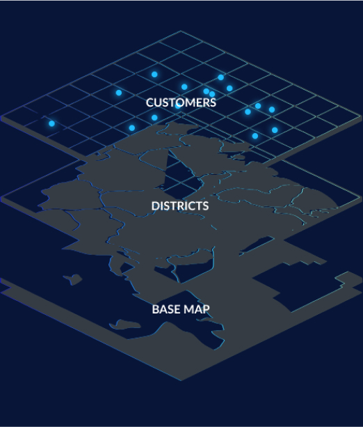
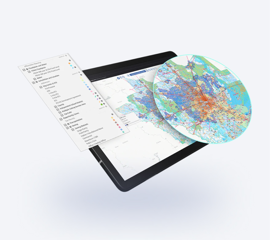
GIS software development, GIS database design, Spatial data analysis, GIS consulting

2D/3D digital mapping, Indoor mapping, Cartography vectorization, Web map development

LiDAR data processing and conversion, Georectification and georeferencing, Vectorization and digitization, Data integration

Data capture and verification, Spatial data analysis, Cartography and mapping consulting, GIS web & app consulting

Floor plans digitalization, Indoor navigation, Building Information Model (BIM)

Data acquisition and digitization, Data conversion, Data cleansing and quality audit, Geospatial modeling and analysis

GIS Services Company - 6
Home » Services » GIS Services Company

GIS Software
Development Services

Map your way to business success with geospatial (GIS) software implementation services.

15
years of
experience
87
implemented
projects
12K+
working
hours
GIS Services Company - 7
GIS Services Company - 8 GIS Services Company - 9 GIS Services Company - 10

Can't make heads or tails of mountains of complex location data organized in spreadsheets? 
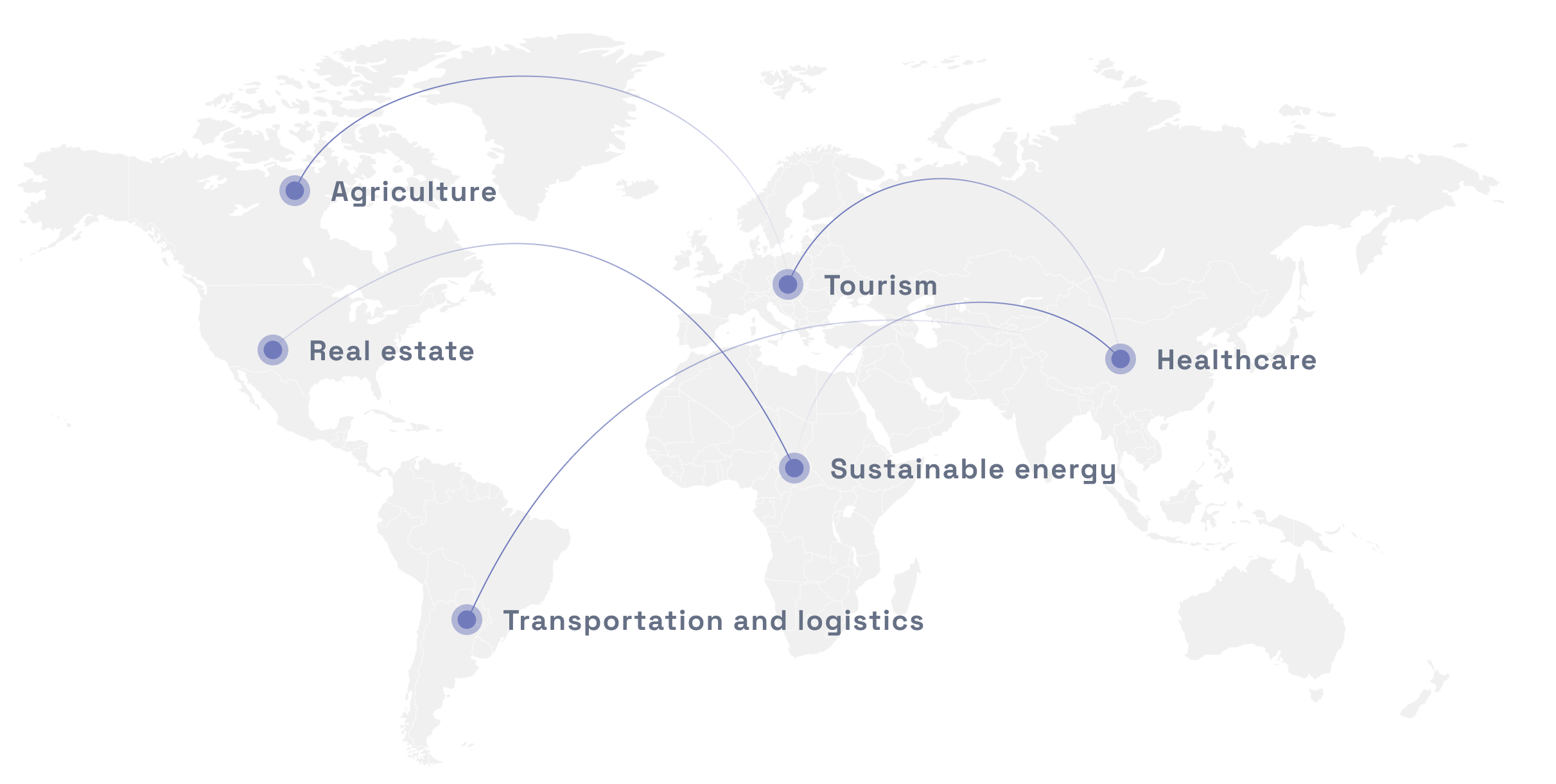
Our GIS software development company will deliver a modern cartography solution in line with your business needs. Store, retrieve, visualize, and analyze all types of geographic and spatial data to gain actionable insights and drive informed decisions.

GIS Services Company - 11 GIS Services Company - 12 GIS Services Company - 13

GIS SOFTWARE DEVELOPMENT SERVICES WE PROVIDE

Embrace the power of GIS on all counts

GIS software development
Build a custom GIS mapping solution with an interactive map for your business using world-known services like PostGIS, UMN Mapserver, HERE or Google Maps.
GIS database design
Develop and integrate a large spatial database for further data conversion and ETL in GeoJSON, GeoTIFF, KML netCDF formats.
Spatial data analysis
Capture and convert geographical data from paper maps, satellite images, and street views into high-end digital models.
GIS consulting
Get an experienced industry consultant on your team to manage digital mapping data and perform geo analyses.
GIS Services Company - 14 GIS Services Company - 15 GIS Services Company - 16

Benefits of our GIS DEVELOPMENT SERVICES

Tell a story your spreadsheets can’t

Boost your user experience with interactive maps

Just like a picture is worth a thousand words, a map is worth a thousand data entries. Our GIS services company will help you organize large volumes of data into an intuitive map allowing your users to click, zoom, and research relevant location data. Your users will find geospatial mapping (with multiple layers) useful no matter the industry you operate in.

Spot opportunities

Plotting anything on a map isn’t enough; only GIS solutions company can help you make sense of that information. Mappitall will help you with any kind of geodata extraction, transformation, conversion, and loading so that you can identify geographic trends and easily visualize your business opportunities.

Streamline your web development

Dealing with freelancers can get messy. Fortunately, Mappitall is a GIS software development agency that takes care of the web development cycle from A to Z. Our engineers collect large amounts of detailed topographic cartographic info and develop an interactive map, GIS system, a web app — you name it! — based on your requirements, which saves you loads of time.

Partner with industry professionals

Mappitall is one of the few GIS software development companies with 15+ years of hands-on experience in both tech (Node.js, JavaScript, Vue, React, PostgreSQL, PostGIS) and geospatial data entry, analysis, and visualization (2D and 3D). Rest assured that your mapping project is in the right hands.

GIS Services Company - 17
GIS Services Company - 18
GIS Services Company - 19

OUR GIS SOFTWARE IMPLEMENTATION PROCESS

Kick-off your project without extra hassle

1
Research & discovery
You contact us for a kick-off call, and our GIS services company gathers your project objectives and requirements: product design elements, GIS tools to be used, preferred tech stack.
2
Project planning
Based on the gathered info from research, we list the project deliverables and present its timelines and budget for your confirmation.
3
Project implementation
As soon as you give us the green light to execute the project, we start developing your GIS solutions. This phase includes geo data extraction, transformation, conversion, and loading into a database, which will serve as a basis for your future product. Libraries are added, and GIS components and overlays are created.
4
Testing
We test your product functionalities and refine them to meet the highest delivery standards. You stay in full control of the process, providing us with your feedback and required changes.
5
Product launch
We release your custom GIS software, and you can request further ongoing support services.
GIS Services Company - 20

Industries we serve

Real estate
Sustainable energy
Transportation and logistics
Agriculture
Healthcare
Tourism

Technologies we use

Tools and frameworks:
GIS Services Company - 21
Mapbox GL
GIS Services Company - 22
Leafletjs
GIS Services Company - 23
ArcGIS Online
GIS Services Company - 24
HERE Map JavaScript API
GIS Services Company - 25
PostgreSQL
GIS Services Company - 26
GDAL/OGR
GIS Services Company - 27
Node.js
GIS Services Company - 28
QGIS
GIS Services Company - 29
JOSM
GIS Services Company - 30
UMN Mapserver
GIS Services Company - 31
Vue.js
GIS Services Company - 32
React
Languages:
GIS Services Company - 33
SQL
GIS Services Company - 34
PHP
GIS Services Company - 35
JavaScript
GIS Services Company - 36
Python
GIS Services Company - 37
HTML
GIS Services Company - 38
CSS
Formats:
GIS Services Company - 39
Shapefile
GIS Services Company - 40
GeoJSON
GIS Services Company - 41
GeoTIFF
GIS Services Company - 42
KML
GIS Services Company - 43
Vector Tiles (mbTiles, .PBF)
GIS Services Company - 44
netCDF
GIS Services Company - 45

Mappitall cases

Discover our GIS success stories

GIS Services Company - 46

GIS toolkit for COVID-19 Vaccines Nearby

The US healthcare authorities build a Vaccines.gov app with all COVID-19 vaccine providers across the country and up-to-date data on vaccine availability.

look into the case
GIS Services Company - 47

GIS toolkit for
Road Lanes

Movement of vehicles in real time.

look into the case
GIS Services Company - 48

GIS toolkit for FuseGIS

A real estate company designs a mapping solution to save time, cost, and resources for brokers and real estate agents.

look into the case
View more cases
GIS Services Company - 49

Want to discuss your project?

Use our GIS software development expertise to design your perfect custom GIS solution.

Reading Time: < 1 minute

    Just contact us:

    Tell us about your project goals, and we’ll get back to you in no time!


    Frequently asked questions

    Where is your GIS development company located?

    Mappitall is a Ukrainian GIS development company based in a small town of Mukachevo in West Ukraine but operating globally. We serve clients across all geographical regions worldwide, including the USA, UK, Canada, Australia, France, Norway, Ireland, Singapore, and China.

    Could you set up a dedicated GIS engineering team for my project?

    Absolutely. You can either hire 1 GIS engineer to enhance your own team or get the whole team of dedicated GIS engineers to address the talent gap for your project. The team of Mappitall GIS engineers will collaborate with you on a long-term basis and take vetted interest in the success of your project.

    For what business types do you provide GIS services?

    We provide GIS services for all business types, from privately held to government-owned organizations. Mappitall has previously had clients with companies of all sizes — from small businesses to enterprises — operating in retail, transportation, tourism, logistics, sustainable energy, and other industries.

    Could you scale existing GIS software?

    You can absolutely scale, improve, or re-build your existing GIS mapping solutions as per your business needs. We can organize complex location data to improve your map accuracy and density. We can also gather data on more locations and carry out a deeper GIS analysis if you wish to expand your map. If you have a web or mobile app, we can add advanced features to help you scale further.

    How much do your GIS software development services cost?

    The cost of Mappitall GIS services depend on which service you wish to use in particular. You can pay a fixed price in case you request end-to-end software development or collaborate with us on a time & material basis and pay per hour of a particular service. Contact us to request a quote.

    How long does it take to conclude a contract with you for GIS services?

    As soon as the project reaches its final phase and you are satisfied with the result, we immediately sign off our partnership. If you wish to conclude the contract with our GIS development company in the middle of the project execution, the notice period shall be negotiated at the beginning of our cooperation.

    What problems can GIS solve?

    GIS can solve many problems regarding the organization of data. Instead of storing all complex geographical data in spreadsheets, GIS solutions structure it into maps, reports, and charts that are easy to interact with. As a result, you can access accurate geographical information, draw valuable insights, and operate efficiently without spending resources on time-consuming tasks.

    What does GIS stand for in business?

    GIS stands for geographical information systems. They allow users to visualize complex spatial and geographical data with the help of GIS mapping.

    What is the difference between GPS and GIS?

    GPS stands for global positioning systems which determine the exact location of an object using satellites. Meanwhile, GIS — geographical information systems — simply record previously collected and converted information on maps.