Application of GIS in Urban Planning & Smart Cities
Application of GIS in Urban Planning & Smart Cities
September 23, 2022
Guides
Author: Volodymyr Ovramenko
Reading time: 13 minuntes
The lucrative advantages, profitability, and successful outcomes of the smart city concept are now making more and more countries start heavily investing in this solution. According to Grand View Research, in 2021 the global smart cities market size was valued at $1,090.64 billion, with a CAGR of 24.2% from 2022 to 2030. In the upcoming years, the components with the largest budget expected are Smart Utilities, Smart Governance, and Smart Transportation.
Regardless of the field, nearly all smart city and urban planning solutions deeply rely on GIS software – an innovative mapping solution that empowers urban experts with enhanced visibility into data.
Analyzing its extensive application in the world’s renowned cities, such as the UK’s London, China’s Shanghai, or Beijing, the importance of GIS for smart city development cannot be overestimated today. Geospatial information is essential for efficient urban planning, as it allows monitoring historical changes, evaluating the feasibility of proposed projects, and predicting their vulnerability in a certain environment.
Based on the extensive knowledge in GIS software development, in this article Mappitall experts will explain the importance and profitability of GIS tools for urban planning. Already decided to develop a custom smart city GIS project? Feel free to review our portfolio or contact us to discuss the details of cooperation.
The application of GIS in smart city planning and urban development has been highly prioritized across a variety of institutions today. Its key advantage – data visualization – helps urban stakeholders of different ranges in the design, realization, and evaluation of urban projects.
Today, GIS tools for urban planning are widely used by:
Projector companies, which are in charge of smart city projects of any kind
City maintenance companies and private enterprises, which are aimed at urban infrastructure services and their improvement
Public administration services, which serve as mediators between the urban environment and citizens
City planning institutions are focused on city infrastructure improvement, its modernization, and digitalization
Policymakers, communities, and citizen bodies, who are interested in smart city development to improve the quality of the life for locals and visitors
Overall, the stakeholders that are extensively deploying urban planning and GIS can be summarized into the following categories – government, private players (infrastructure and service enablers), and citizen body (end-users of the public assets and services provided).
Benefits of Using GIS for Urban Planning & Smart Cities
Implementing the “smart city” concept with GIS solutions has many advantages for businesses, urban environment development, and its habitants. Overall, it enables better resource allocation, and cost optimization, as well as benefits the quality of life of city residents and visitors.
It has also a decent potential for improving and optimizing various aspects of the urban ecosystem, including transport, infrastructure planning, public places, tourist routes, and more. Now, let’s discover the upsides of the application of GIS in urban planning in detail.
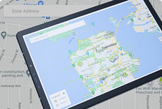
Enhanced Mapping Process
GIS maps feature a single functional system for current and historical data comparison. This helps in accessing the latest site data, and feature-specific information for urban planning, as well as optimizes the data management and expenses.
Increased Access to Vital Information
With GIS for urban planning, stakeholders can efficiently store, manage, and access the required data whenever they need it. Cloud GIS services open up a wide range of add-on benefits for urban planning compared to a desktop option, such as improved collaboration, easier maintenance, and cross-device accessibility.
Improved Teamwork & Communication
A well-planned integration of GIS and smart cities system solutions can facilitate communication between the departments and individuals, helping them to access up-to-date information immediately instead of toggling between documents, hard drives, or multiple storage systems.
Increased Quality and Efficiency for Public Services
Smart city and GIS data analysis are vitally important for improving multiple public services. It performs as a reliable channel between government, private organizations, and citizens. For instance, government officials can share the information while the public has a certain access level to the information they need: urban mapping, transport traffic, etc.
Increased Support for Strategic Decision-Making
Implementing GIS for urban planning opens up a wider range of mapping insights related to a certain region, which is extremely helpful in shaping various urban development strategies. Additionally, GIS maps are widely applied in consulting and forecasting, as the users can test different “what-if” scenarios for developing powerful, long-term development solutions for a certain area.
Application of GIS for Urban Planning & Smart Cities
Having evaluated the overall potential of GIS in urban planning, it’s now time to dive into the examples of its deployment. In fact, GIS mapping technology is extremely helpful across all the stages of planning and development of the smart city system.
The wide functionality of GIS (such as data collecting, processing, management and analysis, spatial planning, and others) can significantly facilitate modeling, planning, building, and management of the city environment.
Site Selection & Land Acquisition
The first and most notable use case of GIS solutions is its ability to analyze, map and design different merits of a certain location compared to its alternatives.
Depending on the site specifics, this can cover soil features, transport traffic, population, vulnerability to disasters, and other aspects that help stakeholders to make data-driven, efficient decisions concerning a specific location and its best exploitation scenario.
Environmental / Legal Compliance
Another great method how to use GIS in urban planning is its implementation to track the impact of urban planning solutions on the environment, forecast the changes, and monitor environmental law compliance in real-time.
The images received from satellites help to organize the city infrastructure with minimum harm to the areas, as well as secure the projects from violating the local laws.
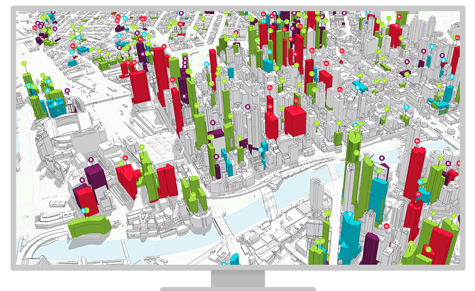
Planning, Design & Visualization
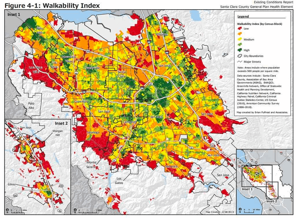
GIS mapping is the ultimate solution for urban development projects, that facilitates and significantly optimizes the planning, design, and visualization of different city-based aspects and scenarios. Efficient information management allows covering different types of data within a single GIS system, including the area’s infrastructure, “walkability”, transit accessibility, environmental impact, and more.
One of the most notable features of GIS is its ability to organize all the relevant urban development project information within a single platform. Thus stakeholders can make data-driven decisions covering the soil data, environmental planning, engineering schemes, project maps, inventory and asset control, and more – all within one system!
Sales & Marketing
Urban developers can also apply smart city GIS to highlight the economic potential of a certain area or promote its perspectives for potential customers. For the existing residents and landlords, this solution can provide more insights into the property’s real value and its profitability in the near future.
Facility Management
Application of GIS in smart cities can easily integrate with the existing facilities management systems and extend the potential of these solutions through a deeper analysis of the data imported. From the urban development viewpoint, this allows getting a full operational awareness based on single-property information, as well as the entire city infrastructure.
Operations & Reporting
One of the GIS key elements for smart city is its ability to track, analyze, and visualize various kinds of information via maps and easy-to-understand reports. Users can interpret certain data in the form of maps, lists, tables, gauges, charts, etc, which allows easier getting a common picture of all analyzed facilities and greatly facilitates the data analysis.
Resource Inventory
GIS platforms are often integrated with other tracking equipment, which allows for reducing the time for land use and environmental data collection. Therefore, urban planners can focus on other high-priority processes, such as area visualizations, location modeling, and more.
Analysis of Existing Situations
Having accumulated a diverse range of historical data, GIS mapping is extremely helpful in reconsidering the current issues and challenges in city development. These are often related to traffic management, facilities utilization, population growth, and more and, usually, require an immediate response from the serving organizations.
Modeling and Projection
One of the most helpful options for using GIS platforms in smart city development is the powerful prediction features. Applying these maps helps stakeholders to test different “what-if” scenarios, that in turn benefit in defining the most efficient urban development model depending on the specific goals and needs.
Development of Planning Options
Thanks to powerful predictive and modeling solutions, many GIS software solutions enable creating of different scenarios of land use, depending on the specific needs and trends within a certain area. This allows choosing the best development option that ideally works for the target location and can deliver long-term benefits.
Selection of Planning Options
Linked to diverse sources of data, GIS solutions in urban planning can greatly benefit the process of selecting the right planning option for a certain location. This means enterprises can utilize the maximum potential of the specific area based on its current characteristics and powerful forecasting. As a result, the stakeholders can maximize the ROIs and improve the overall income from different areas at times!
Decision-Making & Plan Implementation
As mentioned before, GIS solutions are deployed at every stage of planning and development of the smart city concept and are exceptionally valuable at the implementation stage. The real-time spatial data analysis allows stakeholders to adapt to the emerging challenges in the project execution process and make efficient data-driven decisions based on the latest information and forecasts.
Create the Top-Notch GIS for Smart City Development or Urban Planning with Mappitall!
With years of experience in GIS development, Mappitall has been widely known as a reliable provider of innovative mapping solutions across a variety of industries. So far, our team has delivered up to 100 projects that are generating impressive revenues, and dozens of those are still in progress.
In our portfolio, you can find an extensive number of projects for different industries, including agriculture, transportation, real estate, oil and gas, and many other scopes.
Our experts have been thoroughly tracking the trends in urban planning and smart city development, which helps us to deliver the high-end, competitive GIS tools which are applicable for different objectives and needs.
At Mappitall, we are ready to meet different challenges and build robust, functional GIS for smart cities that ideally meet your needs. Already have a project for us to build? Request a quote from Mappitall’s best experts right away and discover the proven ways to improve your business with the right GIS solutions!
Final Thoughts
To conclude, use of GIS in urban planning is now widely applied in cultivating the smart city infrastructure, covering project development, design, visualization, construction, and maintenance. Its scalability, from an individual asset with a building to a virtually global context across all the fields of the smart city, makes GIS an ideal solution for any urban-based project.
The key goal of smart city GIS software is to improve the efficiency and sustainability of urban planning. Apart from optimizing the business workflow, these can significantly improve the life quality of locals and site visitors. Therefore, GIS has become an essential component of collecting, analyzing, and visualizing different city data through mapping.
If you’re considering a feature-rich solution of GIS in urban planning and searching for the right software vendor, entrust this process to Mappitall’s best experts. Our team has vast expertise in developing GIS software across a diverse number of fields, including urban planning, agriculture, transportation, oil and gas, and many other industries.
So far, we have launched over 100 successful GIS-based projects, and with most companies, we continued collaboration in terms of other projects. Now, Mappitall is here to assist you! Do you want to create a smart city GIS project or look for dedicated developers to bring one to life? Then, contact us anytime!
Frequently Asked Questions
What GIS technologies can be used in an urban area?
GIS tools that are extensively used in urban planning include database management, visualization, spatial analysis, and spatial modeling. All these solutions can help in analyzing the geographic data spatially as well as statistically and presenting the results in a comprehensive, simplified, visually entertaining manner.
How has GIS become useful in urban development?
One of the most notable aspects of GIS in urban planning is its ability to better understand the current needs and existing problems of a certain area, and design the most efficient plan to fully get them covered. Geospatial data taken from satellites, aerial photography, and remote sensors enable getting a detailed overview of the land and infrastructure, which is exceptionally important for efficient urban development.
What are the core applications of GIS in urban planning?
In urban planning, the key GIS applications cover a variety of aspects, such as current city data analysis, resource inventory, project modeling and projection, development of planning options and smart city strategies, plan application, design, and mapping of the city suburbs, area monitoring, quality life enhancement and many more.
Where can I find a partner for developing GIS solutions?
With more and more software development companies offering their services online, finding a dedicated team for your GIS project is pretty easy. However, to ensure you’re dealing with professionals that can fully cover your business objectives and needs, make sure to check their portfolio, rates, and client reviews.
The right GIS provider, such as Mappitall, can ensure the product’s relevance and usability for years. Additionally, a trusted vendor can come in handy for the next GIS-based projects, ensuring you’re getting a top-notch product at a reasonable price and costs.
Is the experience of GIS developers required in urban planning?
Of course! Getting the industry-experienced vendors that work with GIS and urban design will help you to get a functional software solution in accordance with the current trends within this field. Additionally, such experts will feature solutions that can better work for your business needs, providing its most efficient performance and delivering the best outcomes.
How much does it cost to build a GIS mapping solution for urban planning?
Whether you’re going to develop a smart city GIS software or more specifically GIS-based urban solutions, the overall project cost is highly volatile. In general, it depends on the project’s complexity, features, development rates, deadline, and many other factors.
To get an accurate estimation of the time, costs, and human resources required for your GIS solutions, it’s recommended to contact your development team. The dedicated GIS developers, such as Mappitall’s, can help efficiently estimate the costs for any GIS in urban planning based on its specifics and client preferences.
Get in touch with us
Want to discuss your project?
Use our expertise to design your custom mapping software solution.
Just contact us:
Tell us about your project goals, and we’ll get back to you in no time!
An entrepreneur and business leader, Volodymyr began his career in the late 1990s at the Laboratory of Geoinformation Systems of the Kharkiv National University of Radioelectronics.
In 2007 Volodymyr created Mappitall, and grew the company from a small agency providing GIS solutions to one of the industry leaders in Ukraine, a reliable technology partner for many international enterprises and top-level organizations around the world.
As CEO, Volodymyr is the driving force behind the company’s strategy and business development, actively working on the development of Mappitall’s business model, attracting more and more talented people who share his vision and mission.