line mapping

GIS Toolkit for
FuseGIS

Project name fusegis

FuseGIS is a US real estate company famous for its unified GIS mapping product which provides valuable insights to make real estate decisions through refined data listings. They partnered with Mappitall to develop software that allows deep GIS data analysis of all tax parcels and properties within Austin, Dallas, Houston, and San Antonio, TX.

  • Country:

    USA

  • Industry:

    Real estate, Tax parcels

  • Project status:

    2021

Visit the website
  • Front end:

    • js framework icon

      Node.js

    • postgress icon

      PostgreSQL

    • vector icon

      PostGIS

    • mapbox icon

      MapboxGL

  • Back end:

    • js framework icon

      Node.js

    • postgress icon

      PostgreSQL

    • vector icon

      PostGIS

    • nodejs image

      Nginx

THE CHALLENGE

Affordable and easy access to reliable location data

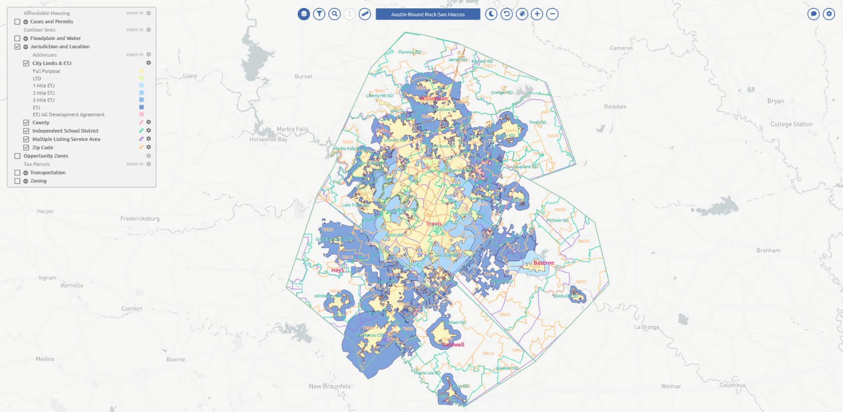
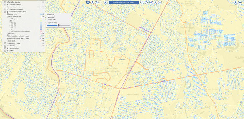
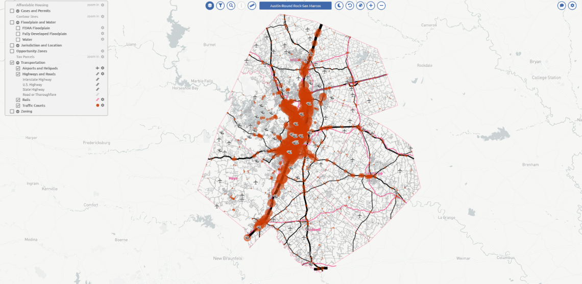
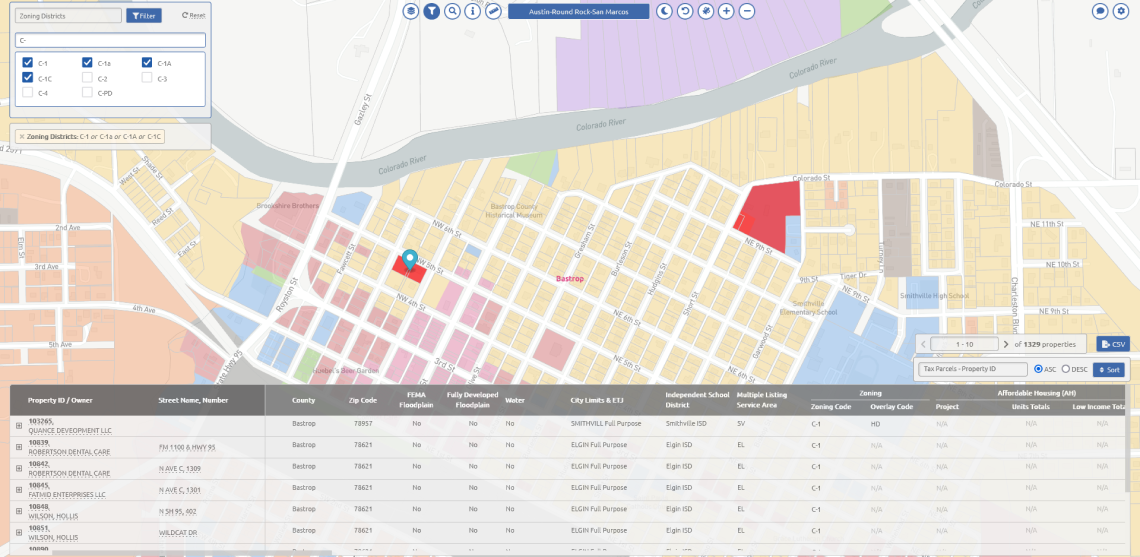
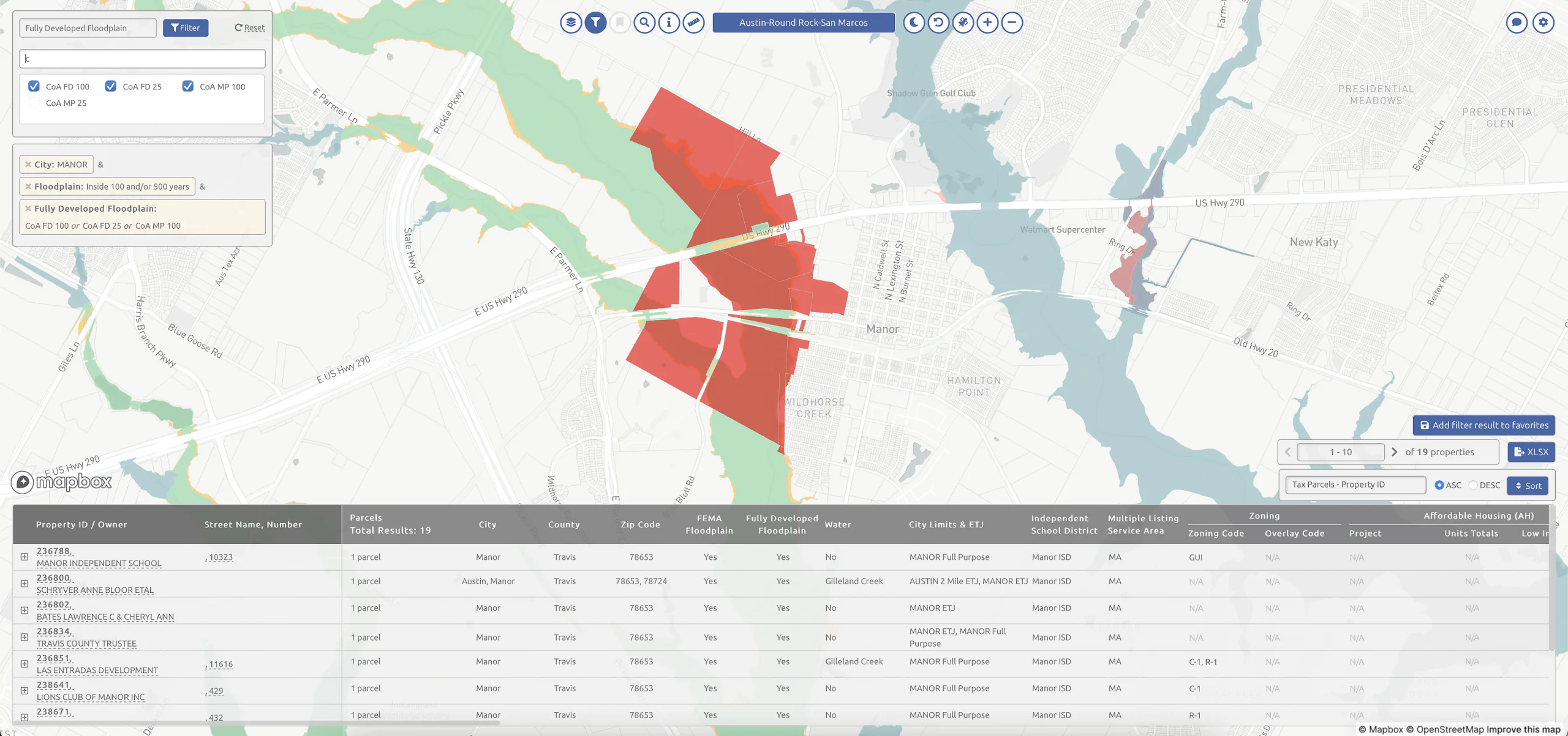
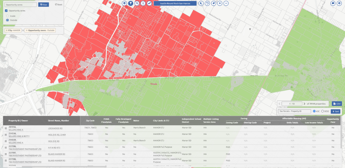
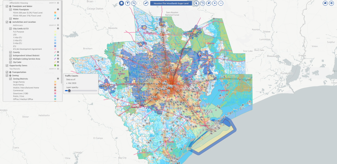
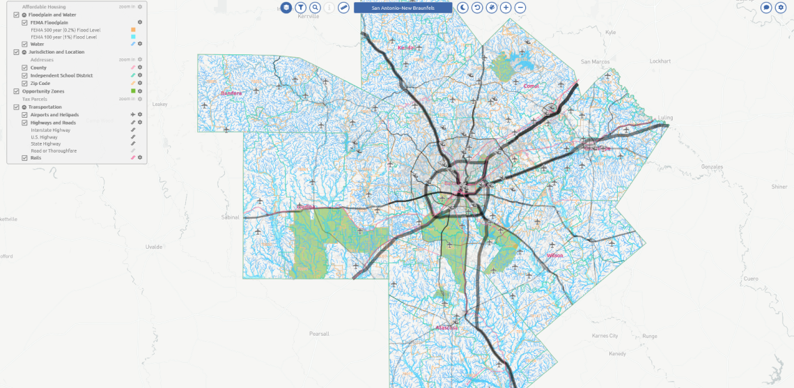
Almost every city or county in the state of Texas (TX) has online services to provide information about Tax Parcels and Properties. However, there is no single registry collecting the data into a single source, especially at the Metropolitan Statistical Area (MSA) level.

For this reason, brokers and real estate agents often face challenges retrieving data on specific properties, taxes, and client deals. Mappitall has helped to develop a reliable, easy-to-use solution that normalizes all data sources across the MSA, including PDFs, into an interactive map and makes it easy for all stakeholders to view, analyze, search, and compare info.

dotted background image

Objectives and Tasks:

  • Collect, analyze, and generate up-to-date cartographic datasets of Tax Parcels from different sources

  • Collect, analyze, and form relevant sets of attributive data on Properties from different sources

  • Collect, analyze, and form relevant sets the actual sets of cartographic data for additional spatial layers

  • Define the relationships between Tax Parcels objects and additional spatial layers based on topological melts

SOLUTION

Interactive map for deep data and GIS data analysis

Having analyzed the client’s requirements, Mappitall has developed a unified Tax Parcels & Properties registry for Austin, Dallas, Houston, and San Antonio counties, TX. The solution places an additional set of spatial layers allowing for a flexible search of all up-to-date info on the locations.

In particular, the solution comprises four main maps: Austin, Dallas, Houston, and San Antonio. Each offers the following vector layers for zoning the region on the map: affordable housing, cases and permits (construction, site plan reviews, subdivision), contour lines, floodplain and water, jurisdiction and location, opportunity zones, tax parcels, transportation, etc. The user can overlay several data layers at once to get a clear picture of the zone or facility of interest.

Besides, Mappitall has suggested adding a few time-saving tools, like the map ruler showing both imperial and metric measurements. The light-dark mode and the ability to layer satellite views on top of the satellite footage render the solution extremely user-friendly.

layers jurisdiction and location
jurisdiction and location zoom map
transportation layers
filter for parcels with specific zoning codes
fusegis floodplains
filter for parcels in an opportunity zone
road mapping
dallas layers panel
houston panel
houston layers panel
san antonio layers
san antonio layers panel

Layers - Jurisdiction and Location

RESULTS AT A GLANCE

Complete data in an easy-to-use interface

The software brings many benefits in addition to saving time and costs for real estate agents. They can obtain data from a wide range of sources (including the offline ones), locate properties and records fast, and make more sound decisions on the acquired information.

dotted background image

FuseGIS users have now received the opportunity to:

  • Display the filtered results both on the map and in the table while further navigating the page

  • Access the layered display of spatial data on the map

  • Export the sorted data to CSV

  • Search for Tax Parcels by address and property ID and display the search results on the map

  • Filter Tax Parcels by spatial and attribute data

  • Take measurements on the map

global gis mapping

Let's bring your project to life!

Use our expertise to design your custom mapping software solution.

Let’s talk

Mappitall cases

Related Case Studio

  • solaris mapping

    Solaris

    A sustainable energy company builds a GIS toolkit
    to inform the most efficient design and placement
    of solar panels
    Look into the case
  • 3D city maps

    Utiligize

    Green energy systems create a data-driven asset management program that reduces electrification
    costs and informs investment decisions
    Look into the case
  • adress list

    Hospital

    Now all US hospital locations in one list. Just select the
    one youneed and we will show it to you on the map
    Look into the case