line mapping

Smart Solar Panel Installation
with a GIS Toolkit

Project name Solaris

SolarPlus is a solar panel company that designs, manufactures, and installs solar modules and provides PV solutions. To take all the guesswork out of the solar panel installation process, the company needed a GIS toolkit that would obtain maximum power generation with minimum equipment costs, while complying with international and state standards.

  • Country:

    Australia

  • Industry:

    Sustainable energy

  • Project status:

    Completed

  • Team size:

    2 people

  • Back end:

    • logo mysql linux

      MySQL

    • Yii (PHP) icon

      Yii

    • nodejs image

      Nginx

    • php icon

      PHP

  • Front end:

    • vue icon

      Vue.js

    • mapbox icon

      MapboxGL

  • Other:

    • google maps icon

      Google Maps

    • arrow icon

      Nearmap

    • red arrow icon

      Metromap

THE CHALLENGE

Saving costs with maximum solar power efficiency

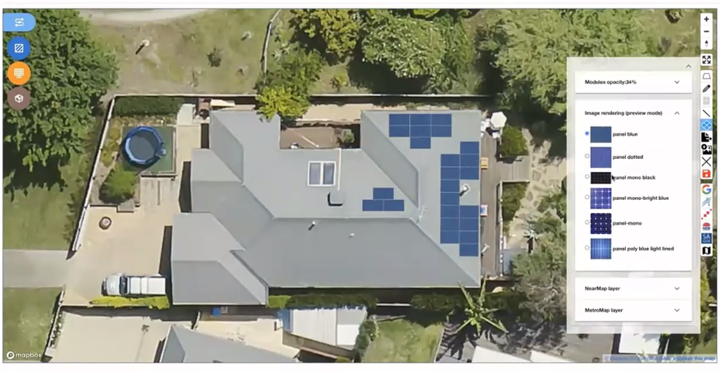
A solar photovoltaic (PV) system is a spatially organized energy installation equipment that ensures the conversion, metering, and accumulation of electricity generated by the panels and its supply to the end consumer.

There are many PV options in the market nowadays, each having its own panel-inverter combination and the value of generated energy. SolarPlus needed a universal tool that would automatically design solar PV considering the customers’ needs and the technological nuances of the equipment installation. The software had to immediately calculate the cost of equipment configuration and visualize the final product on the clients’ facilities.

dotted background image

Objectives and Tasks:

  • Obtain maximum power generation with minimum costs of installation

  • Find the optimal installation option for each individual use case

  • Comply with the recognized international and national standards

SOLUTION

GIS software for residential and commercial solar power plants

Mappitall delivered a GIS tool allowing to quickly select the optimal design, combination, and placement of equipment, calculating the final cost of the project and visualizing the project for the consumer. The tool can apply to both industrial and domestic solar PVs and help install panels on the roofs of houses and on the ground.

Using OpenStreetMap as a cartographic basis for the project, a GIS tool uses both images from online sources (Google Maps, NearMaps, Metromaps, etc.) and the ones provided by SolarPlus (UAV surveys, architecture plans, etc.). Solar panels are mapped onto the given area for the user to see what the installation will look like in reality. The preview function provides a 3D image of the area and a wide array of options for solar panel design.

home satellite photo

End result with panel display palette.

RESULTS AT A GLANCE

Solar installation workflow made easier

dotted background image

Eventually, Solaris GIS spatial analysis and graphic design toolkit allows to:

  • Create photovoltaic systems for both existing and planned buildings

  • Choose the best arrangement of panels in terms of visual appeal and technological features of the structure

  • Choose the optimal layout of equipment, taking into account the angle of inclination of solar panels

  • Select the optimal number of photovoltaic modules, taking into account the load on the power system

  • Find the most illuminated areas of the roof with the help of precise geographic referencing that considers the exposure and angle of inclination of the roof

  • Calculate the cost for various schemes of PV installation

global gis mapping

Let's bring your project to life!

Use our expertise to design your custom mapping software solution.

Let’s talk

Mappitall cases

Related Case Studies

  • 3D city maps

    Utiligize

    Green energy systems create a data-driven asset management program that reduces electrification
    costs and informs investment decisions
    Look into the case
  • adress list

    Hospital

    Now all US hospital locations in one list. Just select the
    one youneed and we will show it to you on the map
    Look into the case
  • coffee points map

    IBO RotaDoCafe

    The famous coffee route on the island of Ibo
    with points of interest
    Look into the case