Best 10 ArcGIS Alternatives and Tips to Choose One
Best 10 ArcGIS Alternatives and Tips to Choose One
October 6, 2023
Guides
Author: Volodymyr Ovramenko
Reading time: 10 minuntes
Geographic Information System is a powerful solution for numerous fields, and there are many GIS platforms. ArcGIS is one of the most popular GIS software platforms. If you are looking for ArcGIS alternatives, this article can help you find software with top functionalities. This list of the top alternatives to ArcGIS includes a detailed overview of their features and capabilities. So read on and select the most powerful alternative GIS software for your project that meets your budget and needs.
What Is ArcGIS?
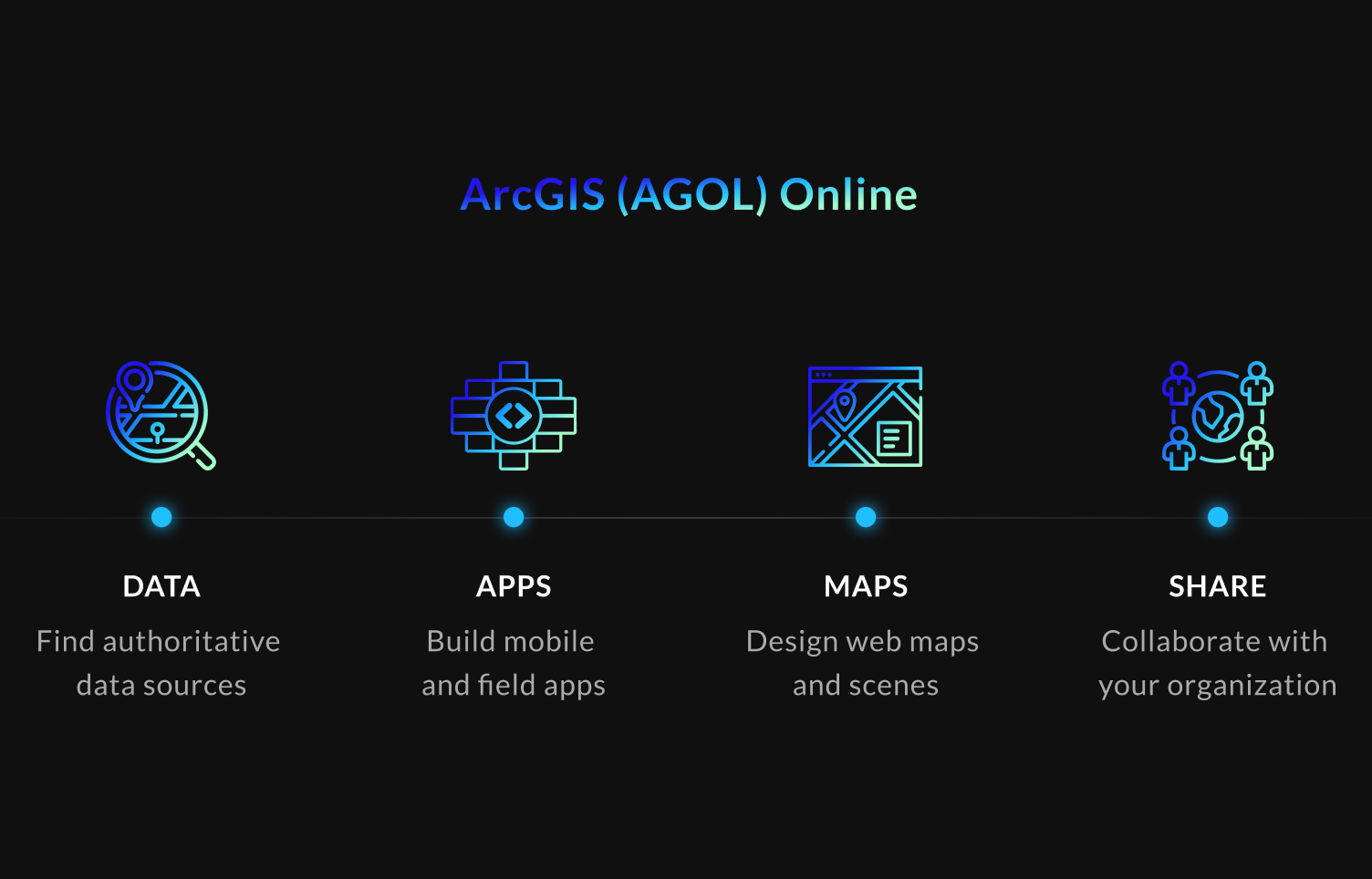
ArcGIS is a geographic information system (GIS) software platform developed by Esri. It enables users to visualize and analyze geospatial information with the help of different tools, like mapping, visualization, spatial analysis, data management, collaboration, and sharing. Online ArcGIS is used in many industries, including environmental management, urban planning, public health, natural resource management, disaster response, and many others.
If you want to find the difference between GIS and ArcGIS, here is the answer. GIS is a broader term that refers to a system used for capturing, storing, analyzing, and managing spatial and geographic data, while ArcGIS is a GIS software platform developed by Esri that provides comprehensive GIS capabilities.
ArcGIS offers unique capabilities, including:
Mapping and Visualization: online ArcGIS allows users to visualize and explore their data. You can create detailed maps in different formats: 2D, 3D, web, and mobile maps.
Spatial Analysis: With this feature’s help, you can bring a location to analytics. Field Operations: another great ArcGIS capability, allowing for improved coordination and efficiency in field operations.
Data Collection & Management: ArcGIS provides tools for managing geospatial data, including collecting, storing, maintaining, preparing, and sharing data in different formats. ArcGIS has many data management tools to help your organization succeed.
Imagery & Remote Sensing: online ArcGIS provides imagery tools and workflows for visualization and analysis.
3D GIS: ArcGIS enables users to create, analyze, visualize, and share data in 3D.
Some of the benefits of using online ArcGIS include:
Comprehensive functionality;
High-quality spatial data and maps;
User-friendly interface;
Integration with other tools;
Robust developer tools;
Cloud-based deployment options;
Collaboration and sharing features;
Compatibility with various file formats;
Strong technical support.
However, there are also some disadvantages to using ArcGIS that urge users to look for ArcGIS free alternatives, including:
High cost;
Steep learning curve;
Resource-intensiveness;
Proprietary software;
Small open-source community.
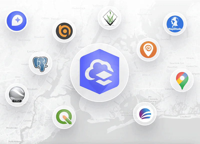
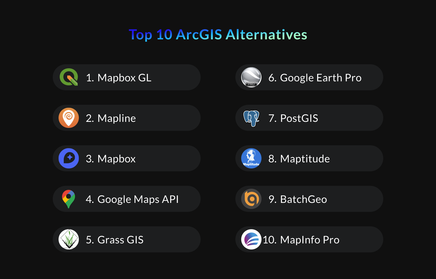
Top 10 ArcGIS Alternatives
Here we collected the best ArcGIS alternatives that have powerful capabilities and are easy to use. There are many more decent options in the market, but these tools are one of the most top-rated and accessible.
#1 QGis
QGIS (Quantum GIS) is one of the best free, open-source alternatives to ArcGIS, allowing users to create, edit, analyze, and visualize spatial data. It offers many advanced features, including a simple and user-friendly interface, compatibility with different operating systems, a range of spatial analysis tools, and tools for data analysis, creation, editing, and management. Here are the pros and cons of ArcGIS vs QGIS. QGIS is cheaper than ArcGIS and has a larger user community, but with less advanced features and weaker integration.
Pros:
Free and open-source;
Easy to use;
Customizable;
Cross-platform compatibility;
Active user community;
Cons:
Limited integration;
Less advanced features;
Less technical support.
#2 Mapline
Mapline is one of the best ArcGIS online alternatives that enables data visualization, analysis, and sharing. Mapline’s features include mapping and visualization, data analysis, data import, collaboration, and customer support. Mapline differs from ArcGIS in price, focus, and customization. It’s cheaper but less customizable and offers fewer GIS capabilities.
Pros:
User-friendly;
Affordable;
Collaboration features;
Comprehensive customer support;
Data visualization;
Cons:
Limited GIS capabilities;
Limited customization;
Limited data analysis capabilities.
#3 Mapbox
Mapbox is a flexible, cloud-based mapping platform for creating customized maps and location-based applications. It’s one of the most popular pro ArcGIS alternatives but lacks advanced data analysis capabilities. Mapbox provides users with tools to create custom maps and import and visualize location-based data; there’s a range of developer and collaboration tools.
Differences with ArcGIS include flexible pricing, a focus on mapping and data visualization, and more customization options.
Extensive customization options;
Developer tools;
Affordable;
Collaboration;
Strong customer support;
Cons:
Limited GIS capabilities;
Limited data storage;
Limited data analysis.
#4 Google Maps API
Google Maps API is an ArcGIS alternative tool allowing developers to integrate it into their applications. Developers can access and manipulate the Google Maps data and functionality. Some of the features of the Google Maps API include map display, geocoding, directions, street view, and places API. Google Maps is more focused on consumer use cases compared to ArcGIS.
Pros:
Easy to use and implement;
Rich feature set;
Integration with other Google services;
Free for most applications;
Cons:
Limited customization options;
Limited control;
Expensive.
#5 Grass GIS
Grass GIS is an open-source ArcGIS alternative that provides geospatial data management, analysis, modeling, and visualization capabilities. This software possesses such features as a powerful scripting interface, different geospatial analysis and modeling tools, integration with other geospatial tools and libraries, and support for various data formats. It differs from ArcGIS in licensing, user interface, and functionalities. Grass GIS has a more complex interface and less advanced features.
Pros:
Free and open-source;
Powerful geospatial analysis;
Modeling capabilities;
Supports different data formats;
Cons:
Steep learning curve;
Limited cartography support;
Relatively unknown in the industry.
#6 Google Earth Pro
Google Earth Pro is one of the greatest ArcGIS alternatives that allows viewing and exploring high-resolution satellite imagery for free. It offers tools for measuring distances and areas and developing custom maps. In addition, Google Earth Pro can be integrated with other Google products. It differs from ArcGIS, as Google Earth Pro is free software but less customizable.
Pros:
High-quality satellite imagery;
Easy-to-use navigation tools;
Support for KML;
Free to download.
Cons:
Limited geospatial analysis capabilities;
Limited customizability support;
Requires an Internet connection.
#7 PostGIS
PostGIS is one of the most popular ArcGIS alternatives that allow for geospatial data storage, manipulation, and analysis. It supports various geospatial data formats and has advanced spatial analysis and modeling capabilities. Compared to ArcGIS, PostGIS is an open-source extension to a database management system.
Pros:
Free and open-source;
Large user community;
Advanced spatial analysis capabilities;
Integration with GIS software and tools;
Cons:
Limited mapping capabilities;
May require third-party support;
Steep learning curve.
#8 Maptitude
Maptitude is one of the top ArcGIS alternatives that provide top-notch data mapping, analysis, and visualization services. It offers a user-friendly interface, intuitive wizards, and advanced demographic and spatial data analysis tools. In addition, it supports different geospatial data formats for import and export. ArcGIS is more broadly used in various industries than Maptitude, while Maptitude is easier to learn and use.
Pros:
Easy-to-use interface;
High-quality mapping capabilities;
Strong spatial data analysis tools.
Support for various data formats.
Cons:
Slow when working with large datasets;
Not suitable for academic or government uses;
May require additional training.
#9 BatchGeo
BatchGeo is known as one of the high-quality alternatives to ArcGIS online that allows users to create maps and analyze data. It has a simple and intuitive interface and basic data analysis capabilities. It is focused on creating maps from data in spreadsheets or CSV files. In addition, BatchGeo provides tools for customizing map styles, markers, and labels. Compared to ArcGIS, BatchGeo is a web-based tool that is primarily designed for individuals and small businesses.
Pros:
Easy to use;
Affordable;
Cloud-based;
Simple geocoding capabilities;
Cons:
Limited customization;
May not be suitable for sensitive or confidential data;
Basic data visualization options.
#10 MapInfo Pro
MapInfo Pro is a powerful ArcGIS alternative that offers top-notch mapping, analysis, and data visualization services. It supports different raster and vector geospatial data formats and has many geospatial analysis and modeling tools. This software allows for working with large geospatial datasets. MapInfo Pro has a more user-friendly interface and advanced cartographic capabilities than ArcGIS.
Pros:
User-friendly interface;
Advanced cartographic capabilities;
Strong database connectivity support;
Easy integration with Microsoft Office.
Cons:
Limited geospatial analysis capabilities;
Limited 3D visualization support;
Limited data formats support.
ArcGIS Collector alternatives include Fulcrum, Survey123, GeoODK, OpenDataKit, OpenMapKit, FieldMove Clino, etc. The most popular ArcGIS Server alternatives are GeoServer, Geonode, MapServer, GeoNetwork, and Mapnik.
ArcGIS Online Pricing
ArcGIS online pricing plans allow users to meet their needs. There are two main plans: for individuals and businesses. Let’s explore them in detail!
ArcGIS for Individuals
Individuals can use ArcGIS for their own or student use.
ArcGIS for personal use is a great option for graduates and GIS professionals. You can build a personal GIS portfolio using this plan. It comes with everything you need for professional mapping. For $100 per year, you will get 90 days of installation-only support, software updates, and unlimited access to self-paced e-learning.
ArcGIS for student use is an excellent choice for students in all areas of study. Students can build a GIS portfolio while in school. Students can benefit from 90 days of installation-only support, software updates, and unlimited access to self-paced e-learning for $100 per year.
ArcGIS for Business
ArcGIS online pricing plan for business suggests starting with a creator user type. Dependent user types include Viewer, Mobile Worker, and Editor.
Creator: This user type allows people to collaboratively build maps and apps, perform spatial analysis, collect data, and share their stories. Five hundred credits are included for free.
Viewer: with this user type, executive officers, managers, and sales managers can view maps and apps created by others securely. No credit is included, so you should buy this currency to benefit from premium services.
Mobile Worker: this subscription is perfect for maintenance foreman, field technicians, and volunteers. Mobile Workers get 250 credits for free.
Editor: if you have one of these job titles: data entry clerk, GIS technician, or data quality engineer, this user type is right for you. 250 credits are included.
FAQ
Will ArcGIS work on Mac?
Yes, ArcGIS is available for Mac computers. However, it is important to note that not all ArcGIS products are fully compatible with Mac operating systems. Therefore, checking the system requirements for the specific ArcGIS product you’re interested in is recommended to ensure it will work on your Mac.
Is QGIS much faster than ArcGIS?
It’s difficult to decide the speed of Qgis vs ArcGIS, as it can depend on various factors, such as the size and complexity of the data, the specific analysis, and the hardware. However, some users have reported that QGIS can be faster than ArcGIS when working with large datasets or running complex analyses. QGIS is open-source software that can be customized to optimize performance, while ArcGIS is proprietary software with a more fixed architecture.
Can QGis open ArcGIS files?
QGIS can open many files created with ArcGIS, such as shapefiles, file geodatabases, and ArcGIS Online services. QGIS uses the OGR library to access many geospatial formats, including those created by Esri software such as ArcGIS. Consider that some more recent versions of ArcGIS may use file formats that are not yet supported in QGIS.
How Mappitall Can Help
Mappitall uses high-quality advanced technologies, including ArcGIS Online, to design a top-notch mapping software solution. We hope this article on alternatives to ArcGIS will help you find the best GIS software for your project. People look for alternatives to different tools and systems as well as alternatives to Esri. If you have any questions on your mapping project, contact our experts. Mappitall can provide you with high-quality GIS development services to reach your objectives.
Get in touch with us
Want to discuss your project?
Use our expertise to design your custom mapping software solution.
Just contact us:
Tell us about your project goals, and we’ll get back to you in no time!
An entrepreneur and business leader, Volodymyr began his career in the late 1990s at the Laboratory of Geoinformation Systems of the Kharkiv National University of Radioelectronics.
In 2007 Volodymyr created Mappitall, and grew the company from a small agency providing GIS solutions to one of the industry leaders in Ukraine, a reliable technology partner for many international enterprises and top-level organizations around the world.
As CEO, Volodymyr is the driving force behind the company’s strategy and business development, actively working on the development of Mappitall’s business model, attracting more and more talented people who share his vision and mission.