PostGIS database is a powerful open-source extension for PostgreSQL. It adds support for spatial data types, spatial functions, and spatial indexes. With PostGIS, you can store, manage, and analyze data in a robust, scalable, high-performance database environment. It is widely used in various apps, including mapping, geocoding, routing, and spatial analysis. In this article, we will explore the power of this app. We will include its features, benefits, and application cases. Whether you are a developer or a data scientist, understanding its capabilities can help you unlock the full potential of your spatial data.
What is a Spatial Database?
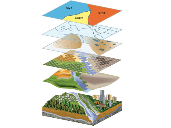
A Spatial Database is optimized for storing, retrieving, and querying spatial data. It includes data with a geographic or spatial component. Geospatial data can be represented in various forms, such as points, lines, polygons, and surfaces. Also, it can be used to represent features such as roads, rivers, buildings, and land plots.
Spatial data types are specialized data used to represent data in a spatial database. These data types include:
- Point: A point is a location in space represented by a pair of coordinates (x, y).
- Line: A line is a series of connected points forming a space path.
- Polygon: A polygon is a closed shape consisting of a series of connected lines that form a boundary.
- MultiPoint: A collection of points.
- MultiLine: A collection of lines.
- MultiPolygon: A collection of polygons.
- GeometryCollection: A collection of other geometric objects such as points, lines, and polygons.
In addition to these basic data types, spatial databases may also support more specialized data types, such as raster and vector data, representing images and geographic features, respectively.
Management systems and extensions are used to work with spatial databases. One such extension, PostGIS, will be discussed in the next paragraph.
Taken from: https://www.esri.com
What is PostGIS?
PostGIS is a spatial database extension for the PostgreSQL database management system. It adds support for geographic objects and functions. In addition, it provides a set of spatial data types, spatial indexing methods, and a wide range of spatial analysis functions and operators.
PostGIS extends PostgreSQL with extra data types like Point, LineString, Polygon, and MultiPolygon. Also, it provides spatial indexing capabilities through a spatial index. This allows for fast retrieval of geospatial data based on their geographic location.
One of the key features of PostGIS is its support for the geography data type. Geography in PostGIS refers to data representation using the WGS84 coordinate reference system. WGS84 is a global reference system based on latitude and longitude. The geography data type in PostGIS allows for an accurate representation of spatial data on a global scale. In addition, it provides several built-in functions for calculating distances, areas, and other spatial relationships between geographic objects.
Using the geography data type in PostGIS also enables more accurate spatial analysis and visualization. It considers the curvature of the earth’s surface. It can be important for accurately representing large-scale geographic features. Overall, PostGIS is a powerful tool for managing and analyzing data in a database environment. It is widely used in various apps, including geographic information systems (GIS), web mapping, and spatial analysis.
In the next paragraph, we’ll discuss how businesses can use PostGIS to make the work easier and more effective.
Taken from: https://fiverr-res.cloudinary.com/
Best Functions for Business
PostGIS provides a wide range of functions that can be useful for businesses that deal with spatial data. Some of the best functions of PostGIS for business include:
- Spatial indexing: PostGIS provides a range of spatial indexing methods, including R-Tree, GiST, and BRIN, which can improve query performance on spatial data.
- Distance calculations: PostGIS provides a range of functions for calculating distances between spatial objects, including ST_Distance and ST_Distance_Sphere, which can be useful for businesses that need to calculate travel times or distances between locations.
- Geocoding: PostGIS provides functions for geocoding addresses to spatial objects, which can be helpful for businesses that need to map customer addresses or other location-based data.
- Spatial aggregation: PostGIS provides a range of functions for aggregating spatial data, including ST_Union and ST_ConvexHull, which can be useful for businesses that need to analyze patterns or trends in spatial data.
- Spatial analysis: PostGIS provides a range of functions for spatial analysis, including ST_Intersection and ST_Buffer, which can be helpful for businesses that need to analyze spatial relationships between objects or create spatial overlays.
- Web mapping: PostGIS can be used with web mapping tools such as OpenLayers or Leaflet to create interactive web maps that display spatial data in a user-friendly way.
As we can see, PostGIS provides powerful tools for managing and analyzing data that can be useful for businesses in various industries, including transportation, real estate, logistics, and marketing.
Sample PostGIS Data Load
Loading sample data into PostGIS is a straightforward process that can help users get started with data analysis. Following these steps, you can load various spatial data into PostGIS and begin exploring and analyzing it using the powerful PostGIS extension’s powerful tools. Here are the steps for loading sample data into PostGIS:
- Download sample data: There are various sources for sample data, including government agencies, non-profit organizations, and online communities. One common source is the Natural Earth dataset, which provides a range of vector and raster data for free.
- Install PostGIS: Before loading data into PostGIS, you must install the PostGIS extension for PostgreSQL. This can typically be done using your operating system’s package manager or downloading the extension from the PostGIS website.
- Create a new database: Once you have installed PostGIS, you can create a new one using the created command.
- Load data: To load data into PostGIS, you can use the shp2pgsql command, which converts shapefiles into SQL statements that can be run in PostGIS.
- Verify data: After loading data into PostGIS, you can verify that it has been loaded correctly by running SQL queries on the database. For example, you can use the following command to count the number of populated places in the database.
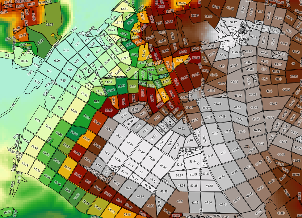
When starting to work with spatial databases, it is important to understand the difference between different types of spatial data clearly. We will talk about this in the next paragraph.
Taken from: https://i.stack.imgur.com
Difference Between Geometry And Geography In PostGIS
In PostGIS, the two main spatial data types are Geometry and Geography. The main difference between these two data types is their representation of spatial data.
Geometry is a spatial data type in PostGIS that represents spatial objects using Euclidean (flat) coordinates. It means that the geometry data type assumes that the earth is flat and does not consider the curvature of the earth’s surface. Geometry is ideal for representing data on a local or regional scale, such as building footprints, road networks, or land parcels.
Conversely, in PostGIS, geography is a spatial data type representing spatial objects using spherical coordinates. This means that the geography data type considers the curvature of the earth’s surface and is better suited for representing data on a global scale. For example, geography is ideal for representing spatial data such as country borders, oceans, or mountain ranges.
Using geography in PostGIS also enables more accurate spatial analysis and visualization, as it considers the curvature of the earth’s surface. For example, when calculating distances between two points on the earth’s surface, the geography data type uses the great circle distance, the shortest distance between two points on a sphere. This is in contrast to the geometry data type, which uses the Euclidean distance, which assumes flat earth and can lead to inaccuracies on a global scale.
The choice between geometry and geography in PostGIS depends on the spatial scale and accuracy required for the specific use case. Geometry is more appropriate for local or regional spatial data, while geography is more appropriate for global spatial data.

Contact us and estimate your project for free.
15 years of experience and success.
Map Editing and Loading GIS Data Into the Database
Map editing and loading GIS data into a database are common tasks in GIS and geospatial data analysis. Here is a general overview of the process:
- Choose the GIS software: Many GIS software options are available, both open-source and commercial. Some popular options include QGIS, ArcGIS, and MapInfo. Choose the software that best suits your needs and budget.
- Create or obtain the GIS data: You can either create your own GIS data or get it from various sources, such as government agencies, non-profit organizations, or online communities. GIS data can include vector data such as point, line, and polygon features and raster data such as satellite imagery or elevation models.
- Open the GIS software: Once you have obtained the GIS data and chosen your software, open the GIS software and create a new project.
- Load the GIS data: Load the GIS data into the software by importing or opening the data files. Depending on the software, you may need to specify the data’s coordinate reference system (CRS).
- Edit the GIS data: If you need to edit the GIS data, use the software’s editing tools to add, delete, or modify features as needed.
- Save the GIS data: Once you have edited the GIS data, save the changes to the data files.
- Load the GIS data into the database: To load the GIS data into the database, you can use the software’s export or conversion tools to convert the GIS data to a format that can be loaded into the database. For example, you can use the ogr2ogr command-line tool to convert GIS data to the PostGIS format.
- Create the database: If you still need to, create a database using a database management system (DBMS) such as PostgreSQL.
- Install the spatial extension: Install the spatial extension for the DBMS. For example, you would install the PostGIS extension.
- Load the GIS data into the database: Finally, load the GIS data into the database using the DBMS’s tools or utilities. For example, for PostGIS, you can use the shp2pgsql command-line tool to load shapefiles into the database.
Editing and loading GIS data into a database can be complex, but it is an integral part of spatial data analysis and GIS. Following steps above, you can create, edit, and load GIS data into a database, which can be analyzed and visualized using the powerful spatial analysis tools provided by GIS software and spatial databases.
To sum it up, PostGIS has become a popular tool for GIS professionals and developers. Mappitall is a GIS and spatial data analysis company that offers a range of services related to PostGIS databases. Mappitall can help businesses design and implement a PostGIS database, load and convert spatial data, perform spatial analysis and geoprocessing, develop custom GIS applications, and provide ongoing support and training. Working with Mappitall can help businesses to maximize the power of PostGIS and unlock the full potential of their spatial data.
FAQ
How to export a view from PostGIS?
To export a view from PostGIS, you can use the pg_dump command-line tool, which is included with PostGIS. This command will create a SQL file named “my_view.sql” that contains the SQL statements to create the view “my_view” in another PostGIS database.
How to edit PostGIS tables by HTML?
To edit PostGIS tables by HTML, you can use a web-based GIS application to view and edit data stored in a PostGIS database. One popular option is GeoServer, an open-source server allowing you to publish and share geospatial data.
GeoServer provides a web interface for editing PostGIS tables and other spatial data sources. Using this interface, you can create, edit, and delete features in the PostGIS tables and modify their attributes.
Is PostGIS the same as PostgreSQL?
No, PostGIS is not the same as PostgreSQL. PostGIS is a spatial extension for PostgreSQL that adds support for spatial data types, spatial functions, and spatial indexes. PostgreSQL is a powerful open-source relational database management system (RDBMS) that provides many features, including transaction support, indexing, and advanced query optimization.
Which database is most commonly used in GIS?
PostgreSQL, along with its spatial extension PostGIS, is one of the most commonly used databases in GIS. Other popular databases for GIS include Oracle Spatial, Microsoft SQL Server, and MySQL.
Why do I need PostGIS?
You need PostGIS to store, manage, and analyze spatial data in a PostgreSQL database. PostGIS provides functions and data types that allow you to store and manipulate geospatial data and perform spatial queries and analyses. Some common use cases for PostGIS include mapping, geocoding, routing, and spatial analysis. If you are working with data in a PostgreSQL database, PostGIS is an essential tool to help you get the most out of your data.
How Mappitall can help you with the PostGIS database
Mappitall is a GIS and spatial data analysis company that offers various services related to PostGIS databases. Here are a few ways Mappitall can help you:
- Database design: Mappitall can help you design and implement a PostGIS database that meets your specific needs. This includes determining the appropriate data model, choosing the right data types and indexes, and setting up the database to optimize performance.
- Data loading and conversion: Mappitall can help you load and convert spatial data from various sources into your PostGIS database. This includes converting data from shapefiles, KML files, and other formats and loading data from web services or APIs.
Spatial analysis: Mappitall can help you perform spatial analysis and geoprocessing tasks using PostGIS. This includes querying and analyzing spatial data, creating maps and visualizations, and running spatial statistics and modeling.
- Application development: Mappitall can help you develop custom GIS applications that utilize PostGIS data. This includes web-based applications, mobile applications, and desktop applications.
- Support and training: Mappitall can provide ongoing support and training for your PostGIS database and GIS applications. This includes troubleshooting issues, providing technical assistance, and offering training and workshops to help you get the most out of your spatial data.
Mappitall can help you leverage the power of PostGIS to manage and analyze your spatial data and develop custom GIS applications that meet your specific needs. Whether you are a small business, a government agency, or a non-profit organization, Mappitall has the expertise and experience to help you achieve your GIS goals.