GIS for Disaster Management and Weather Prediction
GIS for Disaster Management and Weather Prediction
December 2, 2022
Guides
Author: Volodymyr Ovramenko
Reading time: 8 minuntes
When a natural disaster strikes, every minute counts. People might not have enough time to read instructions, but graphics and maps can actually save them.
Among many other industries, emergency management can particularly benefit from geographic information systems (GIS). WorldRiskIndex 2022 calculates disaster risk for 193 countries, and GIS can predict their impact, manage their effects, and help in the rescue/relief efforts. Population, terrain, geology, infrastructure, and structure risk database are integral components of any GIS tool. A variety of communication networks and ground truth allows people to get reliable data on disaster-prone areas.
Having dealt with a variety of solutions for mapping and modeling weather and climate with GIS, Mappitall is an expert company in the field. In this article, you will find all about the application of GIS in disaster management, its market size, benefits, and useful examples you might use for your business.
GIS in Disaster Management Market Size
GIS drives our future. As weather conditions and natural disasters get more severe in the past years, governments and emergency management organizations seek to implement advanced GIS solutions to mitigate the risks and tackle the impact of damages.
Besides, natural disasters have a dramatic socioeconomic impact on local communities, which brings an urgent need for analyzing geospatial data. The technology cannot stop the emergency itself but provides valuable data for preparation and effective consequence management.
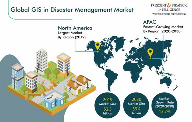
That’s why more companies nowadays rely on GIS for disaster management. The GIS market size is expected to reach $9.4 billion by 2030, showing a CAGR of 13.7% since 2019.
North America is the leader in using GIS for emergency management. The region has sustained serious damages caused by disasters, so its governments allocate considerable funds to prevent the issue. Some of the strongest market geospatial technology players in the region, like the American Red Cross, use RC View which is based on GIS technology and allows for the effective analysis and management of the geospatial data.
By 2030, we’ll witness the fast growth of the Asia-Pacific (APAC) market. Densely populated countries like Japan, China, and India suffer from floods and cyclones. Their disaster management agencies adopt ArcGIS API, ArcGIS, 3D GIS, etc to analyze risks and inform people of the situation.
Problems That Can Be Solved With GIS
The active use of GIS in disaster management is conditioned by the increasing incidence of natural disasters across the world. According to the 2021 Weather, Climate and Catastrophe Insight, natural disasters caused more than $343 billion in economic damage. There are other types of emergencies: human-caused (chemical spills, nuclear radiation escapes, epidemics, explosions), energy and material shortages, and nuclear and biological attacks. And we can integrate geospatial technology for air pollution & control, managing natural resources, forest fires, wastewater, oil spills, etc.
Emergency management activities are focused on protecting life, property, and the environment. Let’s see what we can achieve by applying GIS technology in more detail.
Environmental Data Analysis
Analysis of environmental data can help us understand physical features leading to a critical environmental condition. Such environmental patterns like the steepness of slopes, vegetation, etc are crucial factors for analysis. GIS software can analyze and compare aerial photographs to determine which areas are at risk and need to be safeguarded.
Once the data analysis is over, GIS can be used to mitigate the environmental risks and evaluate the possible hazards. Planners may view spatial data through computer-generated maps and personalize maps to successfully predict dangers.
Rescue and Situation Awareness
GIS in disaster management can also be used for planning the rescue of victims. Geospatial technologies help develop evacuation routes and alternative ways to shelters. GIS systems have already introduced revolutionary changes in the transportation industry. Applied to natural disaster relief efforts, the system might map out the asset locations, such as generators, vehicles, and medical resources, and save their lives.
Recovery Measures
In the aftermath of a natural disaster, GIS technology might help in the recovery efforts. In the short-term recovery plan, the technology should be used for urgent assistance to lead to temporary food, water, shelter, medical care, and emergency generators. Long-term plans use GIS technology to restore all community services and infrastructure.
Damage Assessment
The final issue we can tackle using geospatial software is accounting for disaster costs. These tools facilitate the funds’ allocation process, identifying which areas require major restoration investments.
In the case of Hurricane Irma and Key West, Florida, GIS tracking and reporting ensured the city got its costs reimbursed by the Federal Emergency Management Agency (FEMA) and received the amount of funding needed to make renovations.
Features of GIS Solutions for Weather Prediction
We can use GIS in weather prediction to collect weather-related information like temperature, rainfall activity, wind movement, cloud patterns, and more. Meteorologists can make more accurate weather forecasting using geospatial tools. Thanks to predicting weather with GIS, people can prepare for severe weather conditions or evacuate from the area.
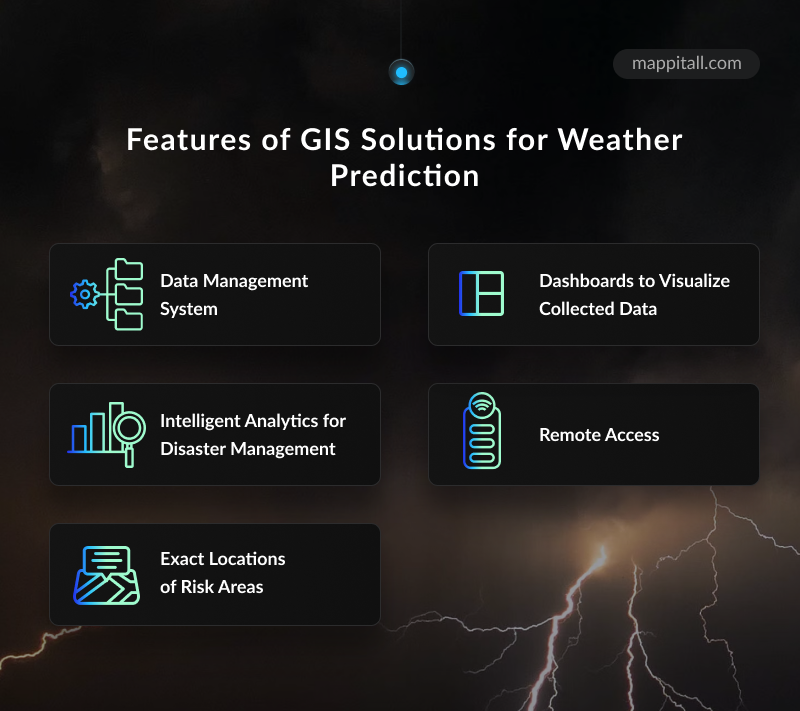
If you decide to take advantage of GIS solutions for weather forecasting, you will get the following features:
Data management system: With a cloud-based system for data management, you can receive and store valuable data about potential weather risks.
Intelligent analytics for disaster management: Advanced analytics tools enable people to improve environmental planning with reliable analysis results.
Exact locations of risk areas: It helps monitor environmental changes and enables people residing in risk areas to prepare for calamity.
Dashboards to visualize the collected data: Having crucial data in a visual format from GIS disaster waste software improves decision-making.
Remote access: You will not have to travel to hazardous areas as GIS tools enable remote access to stations.
Examples of Solutions For Weather Forecasting And Disaster Management Using GIS
There are many cases of weather prediction and disaster management using GIS, but here we collected the most interesting examples for you.
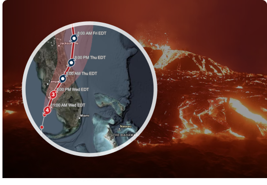
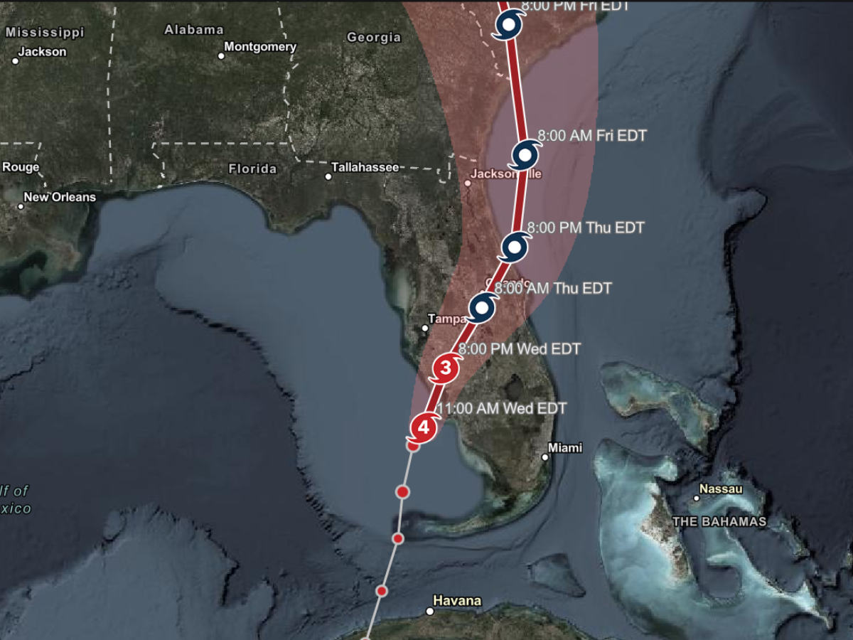
Hurricane Aware Application
Hurricane Aware was developed for ArcGIS Living Atlas by Esri Inc. The application provides the most recent forecast information about hurricanes, cyclones, and typhoons around the world. Information on wind and precipitation impacts and detailed demographics in storms’ paths is available in the app.
Taken from: https://www.fireengineering.com
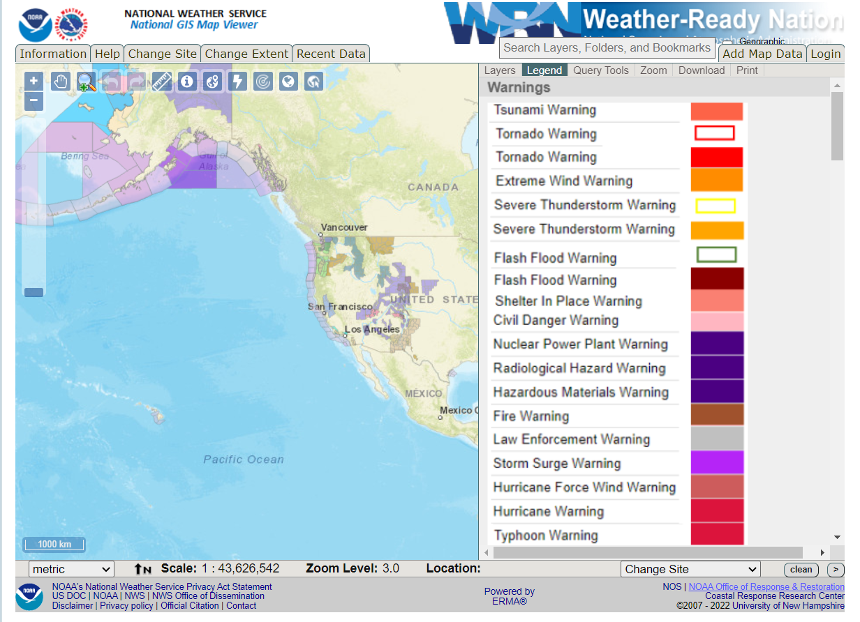
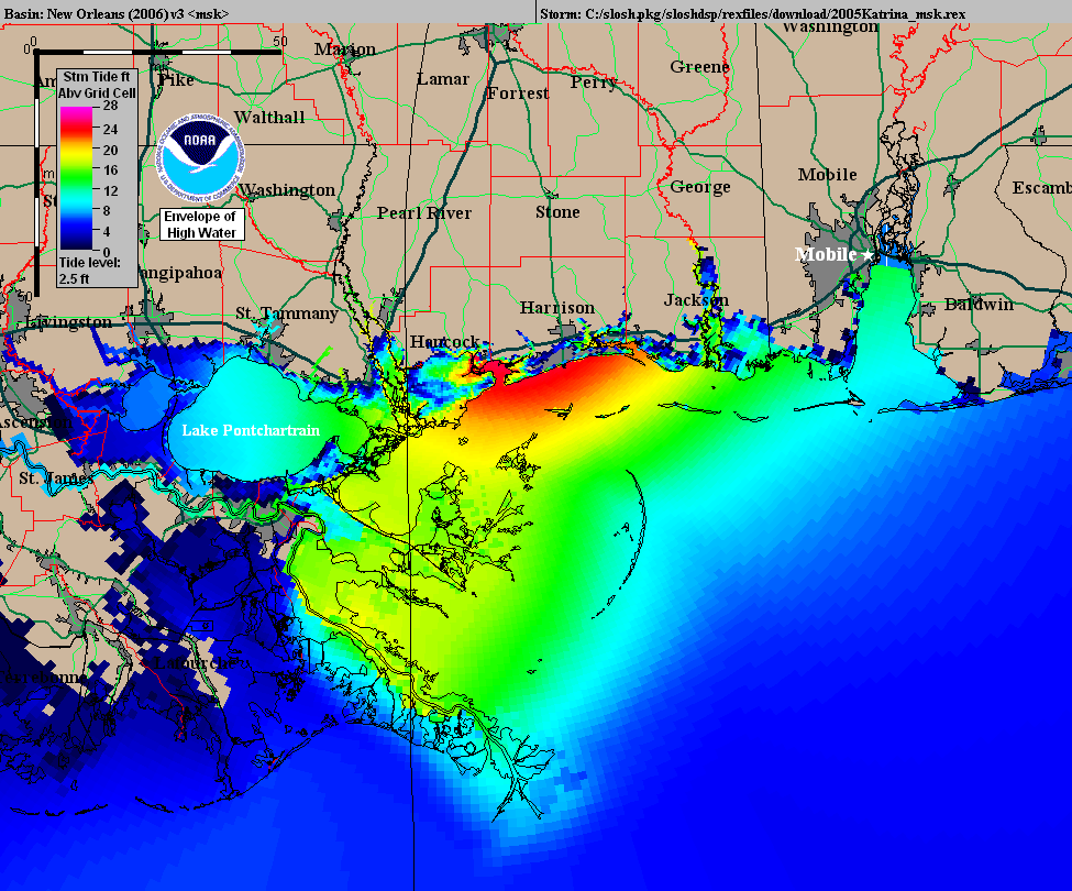
SLOSH Models
The “SLOSH” model is a successful example of a GIS application for natural disaster preparation. It was used by the US National Oceanic and Atmospheric Administration to determine possible areas at risk of flooding during a storm. Interactive National Storm Surge Hazard Maps are created using current wind speed, distance, and direction combined with topography and precipitation predictions.
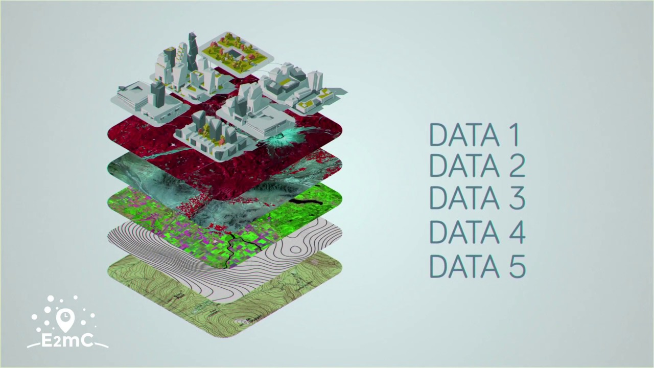
Evolution of Emergency Copernicus Services (E2mC) Project
The research project E2mC is an example of crowdsourcing. Crowdsourced geographic data was obtained with a component “Witness”. The platform enables data acquisition, analysis, and storage in numerous emergencies such as earthquakes and hurricanes.
GIS application in disaster management and weather prediction is paramount to the safety of communities hit by chaos — from identifying vulnerable areas to planning safety measures and post-disaster management.
If you want to keep pace with the latest technological trends in the GIS industry, you should be aware of the cutting-edge software that helps to predict and prevent natural emergencies.
At Mappitall, we know how to deliver top-notch GIS development services to meet the specific needs of every industry. Operating for 15 years in the market, our dedicated experts have extensive experience in developing innovative solutions that boost business performance.
Create a custom disaster management GIS solution for your company with Mappitall. If you want to know more about GIS and weather prediction as well as disaster management solutions, contact us immediately and get professional assistance.
Frequently Asked Questions
How useful is GIS in disaster management?
GIS is a powerful solution for mitigating disasters, preparing for them, responding to them, and assisting in recovery efforts and initiatives. Data analysis, situational awareness, data management, and field operations can help you identify an incident before it actually happens.
What are the advantages of GIS in disaster management?
Using GIS in disaster management can help prepare for a disaster, warn people of an incident, and relieve management and rescue operations.
Which algorithm in GIS is best for weather prediction?
Considering GIS and weather prediction, the most effective algorithm is the combination of weather-tracking software and GIS technology.
What is the importance of GIS application in the management of earthquakes?
GIS technologies help visualize the critical vulnerabilities and damages of a historical site. People can reduce the impact of the disaster and assess it.
Get in touch with us
Want to discuss your project?
Use our expertise to design your custom mapping software solution.
Just contact us:
Tell us about your project goals, and we’ll get back to you in no time!
An entrepreneur and business leader, Volodymyr began his career in the late 1990s at the Laboratory of Geoinformation Systems of the Kharkiv National University of Radioelectronics.
In 2007 Volodymyr created Mappitall, and grew the company from a small agency providing GIS solutions to one of the industry leaders in Ukraine, a reliable technology partner for many international enterprises and top-level organizations around the world.
As CEO, Volodymyr is the driving force behind the company’s strategy and business development, actively working on the development of Mappitall’s business model, attracting more and more talented people who share his vision and mission.