GIS Application Development: The Complete Guide for Non-Coders
GIS Application Development: The Complete Guide for Non-Coders
June 24, 2022
Guides
Author: Volodymyr Ovramenko
Reading time: 12 minuntes
GIS has altered the way that we think about maps: they somehow become much richer in content and used in much more ways.
Have you ever thought about which parts of the convenience store people spend the most time in? Where do most people spend time reading eBooks? Are there areas where environmental polluters and cleaners co-exist and create a balance?
This and many other questions you may have can be discovered through GIS application development. It can help any business, may it be all kinds of commerce, education, or environmental protection.
Read our guide for non-coders to take a closer look at GIS and its purpose, as well as discover how one can develop a GIS software app, what features it should include, and what technologies one might need to create the system that brings real value to the business.
GIS Application and Its Role in Different Industries
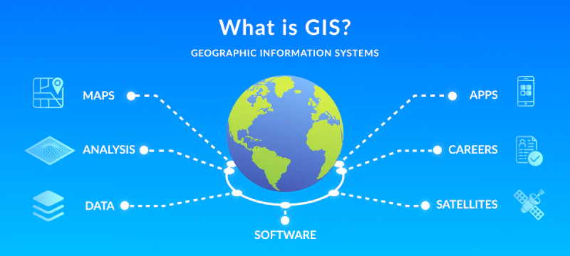
Before we look at geospatial application development, let’s learn about the role of GIS in various industries. GIS or geographic information system is a system that captures, stores, checks, and displays data related to positions on Earth’s surface. You can relate seemingly unrelated data in space and find new interesting patterns.
You have probably used applications that are based on GIS: these are Google Maps or Uber that use street maps, satellite images, Earth 3D models, and information about traffic to create a map that has it all.
Such a system can combine extremely varying types of information and, therefore, finds its way into numerous industries. For example:
Enterprises use GIS to determine the best location for their stores, according to how many competitors are nearby, how many people pass by the area or live there, and whether their target audience lives there
Marketers use the system to decide where to target their ads and understand their consumers in the exact location better
City, state, or federal officials use GIS to find mistakes in urban planning, understand citizens’ sentiment towards different policies, monitor health situations in different areas, create a possible response to natural disasters, etc.
Environmentalists need GIS to track changes in greenery and species population over time, find relations between the increase in polluters and decrease in populations
There is actually no limit to the industries. One can find something to research in every area of life. No wonder that the GIS software market is constantly evolving, as it is expected to grow at a CAGR of 15.2% from 2021 to 2030 and reach $25.5 billion by 2030.
Purposes of GIS Applications
GIS solutions fulfill numerous roles at once since it is a complex product. It creates a streamlined process to manage all data operations within one place and not lose essential information during data transfer between tools.
Here is what you have to include in the development of a GIS-based application.
Data Capturing
GIS applications can work with any kind of data: maps, photos, especially from satellites, digital data (like information about object locations), and data from spreadsheets (such as population demographic).
No matter what sources or format of data are used, a GIS application can overlay them on top of each other.
Putting this data in is called data capture. The digital formats can be added as it is but paperwork should be scanned first. This is the first step in all future processes.
Spatial Relationships
Spatial relationships are about bringing all the information together but making it align, making it fit on the same scale.
For example, if we take a linear map, it will always be a little bit incorrect: when you try to fit a 3D object into 2D, you have to cut somewhere or add another centimeter there. In perspective, it can make an overlay of linear maps and other data based on the Earth’s curved surface show incorrect information.
Therefore, GIS manipulates data and pulls information from several resources to visualize the end result as accurately as possible.
Mapping
Mapping is the creation of an individual map with the chosen layers. You can add all layers at once or just choose some to create a more detailed observation.
The same place on the map can have so many variations of information. You can overlay a street, criminal reports from it, and the number of streetlights or you can take the same street and overlay the income on it. Or you can overlay it all at once to understand what influences the criminality in this area.
Analysis
The whole process does not make sense if you just look at the map without critically analyzing it. You can make conclusions by yourself, of course, and some data scientists prefer it that way.
However, GIS applications can make an automated analysis as well, and sometimes they can find more patterns than a human brain can. Especially when it comes to analyzing historical data or overlaying numerous sorts of information.
The best way is to combine both, to make sure that the conclusion made by the machine is relevant.
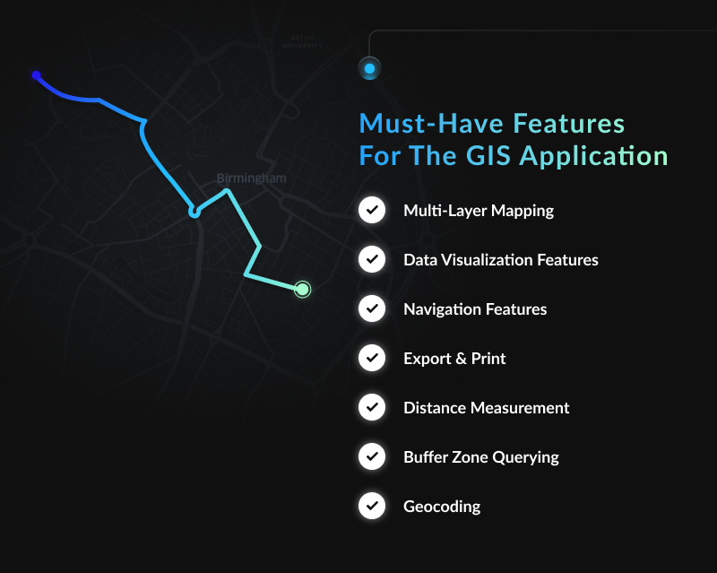
Must-Have Features For The GIS Application
If you want to build a GIS application that covers all the processes, you may want to explore the must-have features.
Multi-Layer Mapping
It is one of the basic features, the core of a GIS system – its capability to overlay different maps with different sorts of information. It should be able to overlay a dynamic number of administrative-territorial units, category or indicator data, static data, names, labels, etc.
Data Visualization Features
Mapping is a form of data visualization so it is an obvious feature. It should be able to plot graphs on maps and data based on GPS coordinates, color territories based on dynamic scaling (e.g. population levels), and attach photos to chosen locations.
Navigation Features
Navigation means moving along the map with overlays, visualizing the end result of capturing and creating spatial relationships. The user needs the opportunity to zoom in and out to study some areas in detail or be able to understand a bigger picture and compare to other zones, as well as to be able to drag the map with a mouse or buttons.
Export & Print
These maps are usually created to show them to a bigger audience. Consequently, it makes sense to make an export feature and let people who do not have your GIS application see the map.
Some people also find it easier to understand the information when it is printed, some need to create posters with it or give it to management (when it comes to urban planners or architects, for example).
Distance Measurement
Distance measurement allows you to measure specific distances between two points on the map and do it based on chosen layers. For example, you can measure distance based on the linear or 3D map, use a roadmap or estimate the distance for walkers.
Buffer Zone Querying
This feature allows users to choose only one area of the map to investigate. It should also allow users to display data analysis from this area only, rather than the entire map.
Geocoding
Geocoding is the core of the development of web-based GIS applications. It is the ability of software to translate address names into longitudes and latitudes. The latter is a more realistic and stable location on the map. Therefore, it will also ensure more accurate data analysis results.
GIS Application Development Process
GIS app development is a lengthy process, with quite some work before, during, and after the development. Here is how you should organize your work.
Project Planning
Project planning is extremely important in the process of GIS software development. You need to define what kind of features you want well in advance since you will have to choose technologies accordingly.
It is important to understand the goals of your development, what kind of data formats you are likely to use, how you want to analyze and visualize your data, etc.
Build the app
Development of GIS apps includes many levels, namely the app itself, libraries and maps, and map components.
The initial design will include basic things like logins, profiles, and user interface.
Libraries and maps will be your sources of data so choose those accordingly. You can add open-source data from APIs or import libraries that are already available (like Leaflet.JS or OpenLayers). Based on the libraries, you should also take care of data manipulation that will fit everything under the one system of coordination.
Map components include titles, scale bars, areas shown, legends, etc.
Add Objects, Overlays, and Layers
This is the point where you add information to the map: locations of buildings and vehicles, temperature data, greenery location, commercial information, crowds or traffic jams points, location of all kinds of waters (underground included), etc.
If you are adding a lot of information, do not forget to add the option to choose what layers to add or remove.
Test and Deploy
After you have added as much information as you need, it is also important to test whether the maps are available on any model of desktop or mobile and whether a different combination of maps is working together without any delays or problems.
After the testing is done and mistakes are fixed, you can deploy the app and let end-users enjoy it. This stage is equally important in GIS mobile app development.
Maintenance
However, it is a must to maintain the GIS app, especially if it contains dynamic data. Some maps get out-of-date, APIs can stop working, there can be new and more powerful APIs, etc.
What Tools Are Used to Develop GIS Applications?
Creating web GIS applications requires special tools, alongside typical app development ones. You work with front-end, back-end, and data management.
As a result, during the GIS web application development process, you may need to:
Leaflet.js, a custom open-source library for creating maps
Turf.js, a library for geospatial functions, such as calculating distances or creating heatmaps
OpenStreetMap, a huge library of data on buildings, roads, natural resources, etc.
OpenLayers, a mapping library that works particularly well with online dynamic maps
GEOS, a tool for spatial operations, including validation and topology features
Boost.geometry, a tool to work with different geometric data types and algorithms
Assimp, a tool that imports 3D data formats
OGR, a tool that imports vector formats
Azul, a tool that helps to create 3D city models within MacOS
QGIS, a package for visualization within GIS tools
Mapbox, a library built on top of Leaflet with more functionality
Why Is It Better to Entrust App Development to a GIS Software Development Company?
GIS apps require a lot of experience in development and data knowledge. There is a lot going on with the right data transfer from libraries and existing maps, spatial relationships, and adequate visualization. It is not the smartest decision to involve regular app developers in building GIS applications.
At Mappitall, we have experts that have 15+ years of experience in creating GIS solutions, both simple ones for regular users and complex apps for data scientists and researchers. Our GIS developers know what libraries to choose for specific goals and add them with accurate overlay. We make sure to use only truthful, working, and regularly updated sources of information and create a seamless user experience even within such complex solutions as GIS.
Approximate Cost of Developing a GIS Software Application
The cost of developing a GIS software depends on numerous factors including the complexity of your business operations, the technical requirements, and the chosen software development builder. Complexity, as well as functionality of necessary features will defiantly be the biggest cost drives. The final cost of the product development would include the cost for the following activities:
Profound analysis of your business
MVP creation and prototyping
UX/UI design
Software development
QA testing
Constant maintenance and support
If you are looking for an experienced GIS software development vendor, Mappitall would be your top choice. Working in the B2B GIS segment for 15+ years, Mappitall creates geospatial mapping tools for businesses of all sizes and is thrilled to work on complicated, atypical projects to address clients’ pain points and address their business needs.
Feel free to book a free consultation with us in order to create a modern GIS mapping solution, hire a GIS consultant, or continue your existing GIS project
Conclusion
GIS applications greatly vary in their complexity, depending on how many data layers there are, what kind of data formats and kinds of information they include, how dependent the researchers are on machine data analysis, etc.
Therefore, you need a special type of development expert to take over complex tasks of data capture, spatial relationships, mapping, and analysis, as well as packing those within a straightforward and intuitive user interface.
Do you want to build your own GIS app? Do not hesitate to contact Mappitall and find those experts effortlessly within a couple of weeks.
Frequently Asked Question
How Do I Create a GIS Application?
GIS web application development requires developers who will be able to handle both regular app creation and data management. After you get your team, you need to plan, create, and maintain the application regularly.
What Are the Stages of GIS Development?
Steps of GIS application development are the following: planning, development of back-, front-end, and data management, testing, deployment, and continuous updating.
How to Reduce the Time to Create a GIS Application?
You can hire more developers to take care of the app development. However, a GIS application is a complex solution that requires a lot of attention to detail to work properly. Therefore, rushing everyone is not the best idea.
What Are the Main Features of a GIS Application?
Main features include multi-layer web mapping app, navigation within the map, data visualization and analysis, exporting and printing, geocoding, and distance measurement.
Get in touch with us
Want to discuss your project?
Use our expertise to design your custom mapping software solution.
Just contact us:
Tell us about your project goals, and we’ll get back to you in no time!
An entrepreneur and business leader, Volodymyr began his career in the late 1990s at the Laboratory of Geoinformation Systems of the Kharkiv National University of Radioelectronics.
In 2007 Volodymyr created Mappitall, and grew the company from a small agency providing GIS solutions to one of the industry leaders in Ukraine, a reliable technology partner for many international enterprises and top-level organizations around the world.
As CEO, Volodymyr is the driving force behind the company’s strategy and business development, actively working on the development of Mappitall’s business model, attracting more and more talented people who share his vision and mission.