Unlock the Possibilities of Mapbox Geocoding: A Comprehensive Guide
Unlock the Possibilities of Mapbox Geocoding: A Comprehensive Guide
August 17, 2023
Guides
Author: Volodymyr Ovramenko
Reading time: 11 minuntes
As our world is becoming increasingly digital, the need for accurate and efficient geocoding solutions is more important than ever. From ride-sharing apps to food delivery services, many of the technologies we rely on every day depend on geocoding to function. One of the most popular geocoding solutions today is Mapbox geocoding, a powerful platform that allows developers to quickly and easily convert addresses into geographic coordinates. In this article, we’ll explore the possibilities of Mapbox geocoding, from its robust feature set to its ease of use, and show you how it can help you build better digital experiences for your users. So, let’s dive in and see what Mapbox geocoding offers and explore React Native Mapbox!
Mapbox Geocoding API
Geocoding is the process of transforming a human-readable address or location, such as “321 Main St, Los Angeles” into geographic coordinates with latitude and longitude. This set of coordinates can be plotted on a map and help users to deal with spatial information. The Mapbox platform enables users to create interactive maps and location-based applications. With Mapbox geocoding, developers can get tools to integrate geocoding functionality into their apps using its API (Application Programming Interface). One of the most popular APIs includes the Mapbox Geocoding API, which provides forward and reverse geocoding services. Besides, Mapbox offers tools for data visualization, location-based analytics, and custom map design. This tool can be useful for various applications, such as real estate, navigation, logistics, and location-based services. For example, Mapbox Tiling Service (MTS) allows users to visualize their data on a map faster and more efficiently. As you can see, Mapbox geocoding provides location-based functionality to applications so that users can easily find, navigate to, and interact with physical locations. In addition, location data is easy to understand and work with.
Data Types
Mapbox geocoder provides different types of geographic features. Consider that some features are available or relevant in all parts of the world. And new types are added if needed to display global administrative hierarchies properly. Here is a list of geocoder data types, listed from the largest to the most granular:
Country (code under ISO 3166-1);
Region (states or provinces);
Postcode (postal codes);
District (prefectures);
Place (cities, villages, municipalities);
Locality (city districts, arrondissements);
Neighborhood(colloquial sub-city features);
Address (individual residential or business address);
Poi (points of interest: restaurants, stores, parks, museums, etc).
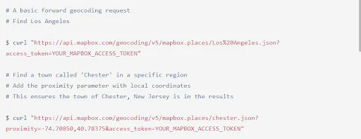
Forward Geocoding
Mapbox geocoder get coordinates (Mapbox forward geocoding) is a simple process that allows you to quickly and easily convert human-readable addresses and place names into geographic coordinates for your mapping and spatial analysis applications. Request parameters include endpoint and search_text. Optional parameters: autocomplete, bbox, country, fuzzyMatch, language, limit, proximity, routing, types, and worldview. Here’s an example of forward geocoding:
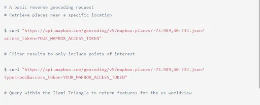
Mapbox reverse geocoding is useful for quickly and easily converting geographic coordinates into human-readable addresses or place names. The required parameters include endpoint and longitude & latitude. In addition, such optional requirements as a country, language, limit, reverse mode, routing, types, and worldview can help refine the results of a reverse geocoding query. Take a look at the example of reverse geocoding:
Batch geocoding is the process of geocoding many addresses or locations at once using Mapbox’s geocoding API. Required parameters include search_text_N, {lon_N},{lat_N}, and access_token. Here’s an example of batch geocoding:
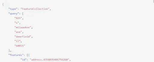
The response to a Geocoding API request is an object that contains properties such as type, query, features, id, type, relevance, properties, text, place_name, center, geometry, and context. Geocoding data is constantly being updated and improved so that values of properties may change within the same API version. Here’s an example of a geocoding response object.
The Mapbox Geocoding API has two parts: the source data to define locations and the tools to search for and return those locations. Here is an overview of how geocoding works in Mapbox:
Textual query input: The user provides a textual query that describes a location, such as an address, landmark, or place name. Use mapboxgl-ctrl-geocoder–input to enter search queries.
Data processing: Mapbox’s geocoding API processes the Mapbox geocoder custom input data and identifies potential matches from a large database of location data.
Geocoding results: The API returns a list of the top matching locations and their corresponding geographic coordinates. The results may include additional metadata about each location, such as its address, place name, and type.
Display: The geocoded location data can be used to display a map, markers, or other visual representations of the location in a user interface.
Mapbox + React Native
In this section, we’ll explore the Mapbox React native tutorial. Mapbox Geocoder React is a React component that provides an easy way to add geocoding functionality to your React web applications using the Mapbox Geocoding API. It allows users to search for a location and returns a list of possible matches based on the search query. A Mapbox React native example involves:
Importing the MapboxClient from the @mapbox/mapbox-sdk library.
Creating a new instance of MapboxClient with a Mapbox access token.
Using the forwardGeocode method to get the coordinates of a location.
With Mapbox React Native Expo, developers can create mobile apps with Mapbox integration using the Expo CLI. So what is Mapbox React native navigation? Mapbox React Native doesn’t provide built-in navigation functionality. Still, it can be integrated with third-party navigation libraries like React Navigation to build a complete navigation system for your app.
Adding Mapview, Camera, and Annotations
To add a Mapview with a Camera and Annotations using Mapbox and React Native, you can follow these steps:
Install the required packages using Mapbox react-native npm;
Import the required components from the package;
Set up your Mapbox access token in your app;
Add a Mapview component to your app;
Add an Annotation to the Mapview component.
Adding Polylines, Polygons, and Markview
To add Polylines, Polygons, and Markers to a Mapview component using Mapbox and React Native, you can follow these steps:
Import the required components from the package;
Add a Mapview component to your app;
Add a Polyline to the Mapview component;
Add a Polygon to the Mapview component;
Add a Marker to the Mapview component.
In addition, to react native Mapbox, you can also use Mapbox gl js geocoder, vue mapbox geocoder, npm mapbox geocoder, etc.
Geocoding API Errors + How to Fix
Geocoding API errors can occur for various reasons, like issues with the Android Mapbox geocoder, Mapbox geocoder style, etc. Their fixing involves identifying the root cause of the error and taking appropriate steps to address it. Here are some common geocoding API errors that you might encounter when using Mapbox’s geocoding API:
Invalid input;
Rate limit exceeded;
Service unavailable;
Invalid API key;
Geocoding result not found.
Follow the link to find possible geocoding API errors and ways to fix them.
Follow the link to find possible geocoding API errors and ways to fix them.
Response body message
HTTP error code
Description
Not Authorized – No Token
401
No token was used in the query.
Not Authorized – Invalid Token
401
Check the access token you used in the query
Forbidden
403
There may be an issue with your account. Check your Account page for more details. In some cases, using an access tokens with URL restrictions can also result in a 403 error. For more information, see our Token Management Guide.
Not Found
404
Check the endpoint you used in the query.
Not Found
404
No search_text was provided in the query.
Bbox is not valid. Must be an array or format [minX, minY, maxX, maxY]
422
Check the format for bbox, where the first coordinate pair should refer to the southwestern corner of the box and the second pair should refer to the northeastern corner of the box.
Bbox {minX/maxX} value must be a number between -180 and 180
422
Check the formats of minX and maxX for bbox.
Geocoding Restrictions and Limits
Mapbox has restrictions and limits to ensure that its geocoding API is used efficiently and maximizes service stability. Some of the restrictions and limits that apply to Mapbox’s geocoding API include:
API key requirement;
Rate limits;
Geocoding quality;
Data availability;
Usage quotas.
Geocoding API Pricing
Mapbox Geocoding API pricing is based on usage and the specific plan that you choose. There are various pricing plans, so choose the one to meet your needs. With Mapbox, you only pay for what you use. As your usage grows, you’ll automatically get volume discounts and additional discounts for annual commitments.
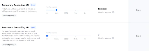
Temporary geocoding API allows up to 100,000 requests for free. If you want to find more places, addresses, or points, the cost per 1,000 requests rises to $0.75 for 100,001 – 500,000; $0.60 for 500,001 – 1,000,000; $0.45 for 1,000,001 – 5,000,000; if 5,000,000+ contact sales. Permanent geocoding API results are available for your own personal or business use. There are no free requests, so you should pay $5.00 for every 1,000 requests if their number doesn’t exceed 500,000. For example, if you have 500,001 – 1,000,000 requests, pay $4.00, and contact sales if you make 1,000,000+ requests. You can use Mapbox geocoder without a map and Mapbox geocoder outside the map, but make sure to review the pricing plans and terms of use or contact customer support. Here you can see Mapbox support pricing plans:
Mapbox Free
This plan is available to developers. Mapbox support provides them with free developer docs, API status notifications, and stack overflow.
Mapbox Essentials
Customer support is provided by product experts as well as email support, guidance on proper API syntax, and submitting cases via the web for $50 per month.
Mapbox Business
The plan costs 10% of monthly spending ($500/mo minimum). This option offers prompt email support, response within 4 hours for emergencies, and technical best practices, tailored to your use case.
Mapbox Premium
This custom plan is designed for high-volume geocoding usage and provides custom pricing based on your specific needs. You can benefit from a private Github repository, a dedicated support engineer, and fast emergency response. In addition, developers can use a React Mapbox library for integrating Mapbox maps into mobile apps.
FAQ
Why is geocoding important?
Geocoding is an important computational process for obtaining geographic coordinates (latitude and longitude) from human-readable location data. This data can be used to calculate distance, proximity, etc., or locate the corresponding place on a map. Geocoding is widely used in various industries, including logistics and transportation, marketing and advertising, real estate, and many other organizations and companies, to analyze and visualize spatial data.
Where does Mapbox get data from?
Mapbox sources its data from various data providers and its community of users through its Mapbox Studio platform. Some of the data sources that Mapbox uses include OpenStreetMap (OSM), satellite imagery, public datasets, government sources, and private data providers (OpenAddresses). The versatility of data sources ensures that Mapbox maps and location-based services are accurate, up-to-date, and comprehensive.
What is the difference between Mapbox and Google Maps?
Mapbox and Google Maps are web-based mapping platforms that can be used for geocoding, routing, and location-based services. However, there are some key differences, including customization, price, data sources, and functionalities. Both platforms are great, so consider your specific needs when choosing between Mapbox and Google Maps. Mapbox offers more customization options, data visualization and styling flexibility, and flexible pricing. Google Maps is better for users seeking robust navigation and point-of-interest search capabilities.
Where inside the Mapbox do you add locations?
To add locations to Mapbox, you should sign up for a free account on Mapbox and download the GeoJSON file that contains the location data. Then use the data to create custom markers, labels, and other map features. Once data is prepared, you can create a map style and add interactivity.
Is Mapbox geocoding rate limited?
Mapbox geocoding has limits on the number of geocoding requests that can be made within a certain time period. In addition, the platform offers different pricing plans that provide different levels of geocoding capacity and rate limits.
Geocoding with Mappitall
Mappitall is a great solution for custom and smart mapping. Our experts specialize in web app development and can help you with interactive map development, spatial data visualization, Node.js, Python, Vue, React app development, and vector tiles in web apps (Mapbox, mbTiles, PBF). So do not wait to contact us for professional consultation and Mapbox React Native development services.
Get in touch with us
Want to discuss your project?
Use our expertise to design your custom mapping software solution.
Just contact us:
Tell us about your project goals, and we’ll get back to you in no time!
An entrepreneur and business leader, Volodymyr began his career in the late 1990s at the Laboratory of Geoinformation Systems of the Kharkiv National University of Radioelectronics.
In 2007 Volodymyr created Mappitall, and grew the company from a small agency providing GIS solutions to one of the industry leaders in Ukraine, a reliable technology partner for many international enterprises and top-level organizations around the world.
As CEO, Volodymyr is the driving force behind the company’s strategy and business development, actively working on the development of Mappitall’s business model, attracting more and more talented people who share his vision and mission.