Historically, transportation and delivery industries have been always dealing with drastically changing routing plans. In fact, routes have already become one of the key aspects that impact the entire industry development. Those that were speedy and efficient once can suddenly be rendered slow and congested.
The specifics of the transportation industry require extreme flexibility and awareness. To meet the emerging demands of different clients across the globe, companies should always keep themselves in the loop about the new trends and technologies that have appeared. This implies process automation, spatial data analysis and management, route planning, and more.
To stay on top of current routing systems, transportation, and delivery services have turned to geospatial information systems (GIS) solutions, which use geospatial data to uncover the most efficient routes between the dispatch and destination points for a given shipment or travel line. At the same time, it allows easier satisfaction of customer demand with the increasing deliveries of all the types.
In this article, we’ll uncover the basics of GIS for transportation, including.
As a business owner, you’ll discover how GIS can be applied and used for different fields within the logistics industry.
As you know, a geographic information system (GIS) is a system designed to capture, store, manipulate, analyze, manage and present spatial or geographic data. Nowadays, many businesses across different fields start realizing the potential of GIS solutions. It is already present in agriculture, disaster management, urban planning, marketing, oil spill, and, of course, the transportation industry.
Such an increasing demand for GIS across the industries has also impacted the GIS market share. According to the recent market overview by Research and Markets, by 2030 the global GIS market value will increase to $24,607.7 million, from the start point of $8,185 million in 2020. The largest consumers of GIS are located in North America, mainly because of the advanced IT infrastructure and high technical awareness. As for the most typical scopes of use, geographic information systems are mainly helpful for the healthcare, disaster management, and defense sectors.
Due to its full relation to mapping and visualization, the capacities of GIS in transportation cannot be overlooked. With the help of GIS, enterprises, governments, and consulting entities can enhance a variety of operations. For instance, this mapping solution is applied for cost optimization and service improvement, route planning, forecasting, and more. Partner companies can empower their cooperation and better exchange up-to-date transportation data. At the same time, the end consumers can see positive changes in service pricing and the delivery time
Once we’ve learned the basics of GIS within the current field, it’s time to discover how GIS can be useful in transportation and which industry-related authorities can make the most of its implementation.
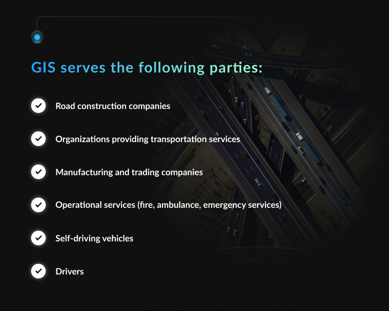
Who Needs GIS Solutions to Solve Transportation Problems?
Probably, you’ve already got an idea of application of GIS transportation data, it would be also great to uncover whether your business really needs this technology. To ensure the GIS platform is worth your time and resources, let’s review the ways it’s applied across different transportation authorities.
Road construction companies. GIS maps for transportation help in modeling and forecasting the upcoming construction projects. This enables cost-effective, convenient, and functional urban planning at no harm to the environment. GIS solutions road construction also benefit from reducing the traffic capacity on the roads, rails, and by the sea, enabling the creation of the most effective road infrastructure for traffic management and control;
Organizations providing transportation services. GIS data also help in logistics, allowing transportation companies to better plan the routes, optimize the delivery costs and reduce transportation expenses;
Manufacturing and trading companies. Similar to transportation service organizations, powerful automotive GIS applications enable more efficient logistics planning. This allows companies to reduce the costs of product shipping and time on their delivery while increasing their revenues simultaneously.
Operational services (fire, ambulance, emergency services). GIS applications also provide deep expertise in route planning, which is essential to deliver immediate emergency services in case of an accident. So, the operational authorities can provide timely assistance to the affected parties;
Self-driving vehicles. In the long-term perspective, GIS solutions can be also applied to self-driving vehicles, conveying passengers to their destination with minimal human intervention or room for error;
Drivers. GIS-powered technologies are also irreplaceable for drivers, as those benefit route planning. Moreover, the up-to-date maps allow adjusting the routes efficiently, even with no expertise in that field!
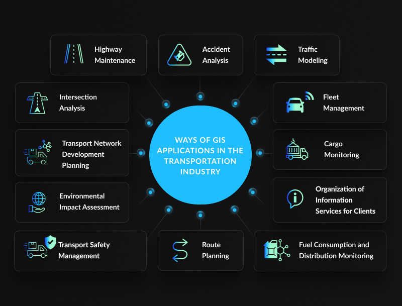
Ways of GIS Applications in the Transportation & Logistics Industry
Once you’ve ensured the technology ideally fits your target type of activity, it’s now time to discover how GIS can help to develop your business. In fact, there are many scopes for GIS applications, that cover data management, analytics, modeling, and planning aspects.
Over the last few years, highway maintenance has evolved to a new level, becoming much easier and more cost-effective with time. Satellites can show real-time images of highways and warn about the critical areas that are experiencing challenges. This technology significantly simplifies various decision-making aspects for the government and relevant authorities. Finally, the GIS transportation data about the highway structures are accessible and versatile, which is essential for road planning.
Accident Analysis
Transport accidents are one of the most common issues the transportation industry faces on a daily basis. With the closed-circuit television cameras (CCTV) and satellites applied, it becomes extremely easy to address the location and get timely emergency help. In this aspect, GIS can act as a source of a report in the event of an accident, helping to identify the causes, participants, and factors that entailed it.
Traffic Modeling
In times of heavy traffic, the government and other relevant authorities started considering efficient solutions to keep up with the problem. For this reason, most countries have applied GIS in transportation to improve traffic management and structure design.
GIS platforms enable traffic management modifications for the different vast road networks available in cities and towns. As a result, GIS solutions for highway and road management not only have a positive impact on traffic congestion and heavy congestion, but also improve the construction of air and rail tracks.
Route Planning
When it comes to the route planning process, GIS and transportation always stand together. Planning new and improving the existing roadways is one of the key ways to improve traffic management while decreasing its costs.
GIS tools can help to determine the road surface quality, making a notable difference in fuel consumption, transport maintenance as well as time management.
Environmental Impact Assessment
Transportation GIS data is widely applied for planning and construction of the environment-friendly roads, railways, or airports. With its assistance, experts can assess the potential damage to the local ecosystems and animal life.
It allows getting a better idea of the existing ecosystems before the construction is started. Additionally, powerful GIS processing solutions can predict the potential impact of construction. That is exceptionally important for both transportation and environmental protection authorities.
Transport Safety Management
Another key aspect of GIS in transportation planning is the capacity to formulate regulations and inform the public on how to use certain transport facilities. For instance, drivers can receive information about various crossroads and even railway crossing points. This can in fact significantly reduce the chance of accidents and becomes essential for any country.
GIS in transport planning can also be valuable in gathering information about any point on a roadway, on a patch of railroad track, or near a transportation facility. This greatly helps to plan the road ahead and prevent harm from coming about.
Fuel Consumption and Distribution Monitoring
Fuel consumption is an essential GIS application in transportation that impacts the cost-efficiency of any business. Basically, the application of GIS in transportation can be a huge money-saver for any company that operates a sizable fleet. Along with the mileage and fuel savings, it allows getting a longer service life for the vehicles. The fewer miles a vehicle must drive to perform a service, the less engine exertion will be each day. As a bonus, business owners can greatly reduce the repairs and servicing expenses that are required on a less frequent basis.
Thus, geospatial data can be quite a lucrative way to reduce the mileage by saving your company money on fuel and vehicle service.
Fleet Management
GIS solutions are not solely implemented into road and rail mapping: it is widely used for fleet management as well! For many fleet operators and enterprise owners today, having a vehicle tracking system is no longer a “nice-to-have option” but rather a “must-have” issue. These tools enable monitoring fleets from any location and getting detailed information about them. Additionally, it covers the asset management applications that deal with ship financing and maintenance, fuel management, and so on.
Cargo Monitoring
GIS maps for transportation can be applied by businesses that may use them to prevent theft and locate merchandise. Typically, it is designed for internal use, where each cargo or container it’s shipped in has its unique XY coordinates, origin, destination, contents, mode of transport (ship, truck, or train), and other related data.
Whether the cargo is shipped by road, rail, or sea, this technology allows tracking the delivery process until it reaches its final destination.
Intersection Analysis
Intersection analysis is one more mapping aspect mostly implemented into GIS cloud solutions to process large amounts of data. This is highly valuable for urban traffic, as it helps to address traffic volume challenges through different angles. By testing each of the intersection degrees, business owners can verify the efficiency of the proposed approaches and strategies for transportation.
Transport Network Development Planning
GIS can also perform structure simulations before the actual construction process. Experts can get a 3D projection of the project plan, as well as compliment them with drone photographs of the ongoing construction. Moreover, GIS technologies allow the creation of design templates that can be later applied for constructing future highways, airports, or ports. This can greatly benefit tracking the process and evaluating the progress of transport network development.
Organization of Information Services for Clients
Improvements in routing with GIS make it extremely possible to provide better customers service. They’ll become more aware of the accuracy of your delivery services as well as the rates you provide those for and improve the client loyalty.
Once you improve the product delivery, it becomes possible to ramp up the capacities and make your company way above the competition.
How to Improve Your Transportation Business With Mappitall?
Mappitall is the world’s most famous GIS solutions provider with over 15 years of experience working across many industries. So far, we have successfully delivered nearly 100 innovative projects for our clients, and are not going to stop on the achievement. Among those, we have dozens of GIS solutions for transportation, which have significantly optimized business development and growth. Highway management, traffic modeling, accident analysis, and customer service are only a few of the examples created by Mappitall.
We have a personalized approach for each of our clients and are always open to discussing the improvements they need. So, regardless of the project complexity, you’re guaranteed to get functional and effective GIS software for transportation that ideally meets your business.
If you’re ready to get started developing your ideal GIS mapping solution, contact us right away!
For the transportation industry, speed and reliability are the core aspects to focus on today and in the future. Whether it’s public transportation or product shipping, it’s essential to get from the place of dispatch to the final destination with no setbacks along the way. At the same time, companies should always search for optimization opportunities within the field while making the services more affordable for the clients and competitive in the market.
As you can see, custom GIS solutions for transportation can make revolutionary changes in this industry. From route and traffic modeling to fuel consumption and cargo monitoring – GIS systems are the key technology in this industry. Needless to say, to keep your business competitive and efficient, you must stay on top of these changes and make every effort to improve.
At Mappitall, we know how essential it is to successfully meet the challenges in the transportation industry. Our dedicated creators develop innovative solutions and advanced technologies to businesses forward, from cargo transportation and trucking to various relocation services. Already have a GIS mapping project to develop? Contact us today to discover how to make it real right away!
Frequently Asked Questions
Discover the most common questions about GIS in transportation to get a better idea of how to execute this technology in your business!
How can GIS be used for transportation?
In transportation, GIS technologies allow a better understanding of a variety of processes. These include travel behavior analytics, accident analysis, road network mapping, vehicle cost analysis and capacities, and many more. Whether you need a tech solution for passenger, product, or customer transportation, GIS software for transportation will be a must-have.
Can GIS help with transport planning and traffic management?
GIS transportation analysis can also benefit delivery planning, as it helps to greatly reduce the workload even on the most congested days. Typically, it helps to plan delivery volumes to each customer, regardless of distances and traffic conditions in a given area. Additionally, it enables the management of shipment volumes on a daily, weekly, and monthly basis with greater accuracy.
What impact might GIS have on future projects in transportation?
In the future, GIS solutions are expected to enhance the performance of the transportation industry overall. There are many opportunities for implementing big data analytics and spatial analysis within the industry today. In addition, GIS and transportation will contribute to developing smart cities and smart transportation solutions, as well as provide new data sources to better understand mobility patterns.
How can GIS help to reduce costs in transportation?
GIS technologies allow making instant decisions, effective planning, and risk management. Thus, various institutions within transportation can quickly react to the changing conditions and share real-time data while optimizing their expenses.
Get in touch with us
Want to discuss your project?
Use our expertise to design your custom mapping software solution.
Just contact us:
Tell us about your project goals, and we’ll get back to you in no time!
An entrepreneur and business leader, Volodymyr began his career in the late 1990s at the Laboratory of Geoinformation Systems of the Kharkiv National University of Radioelectronics.
In 2007 Volodymyr created Mappitall, and grew the company from a small agency providing GIS solutions to one of the industry leaders in Ukraine, a reliable technology partner for many international enterprises and top-level organizations around the world.
As CEO, Volodymyr is the driving force behind the company’s strategy and business development, actively working on the development of Mappitall’s business model, attracting more and more talented people who share his vision and mission.