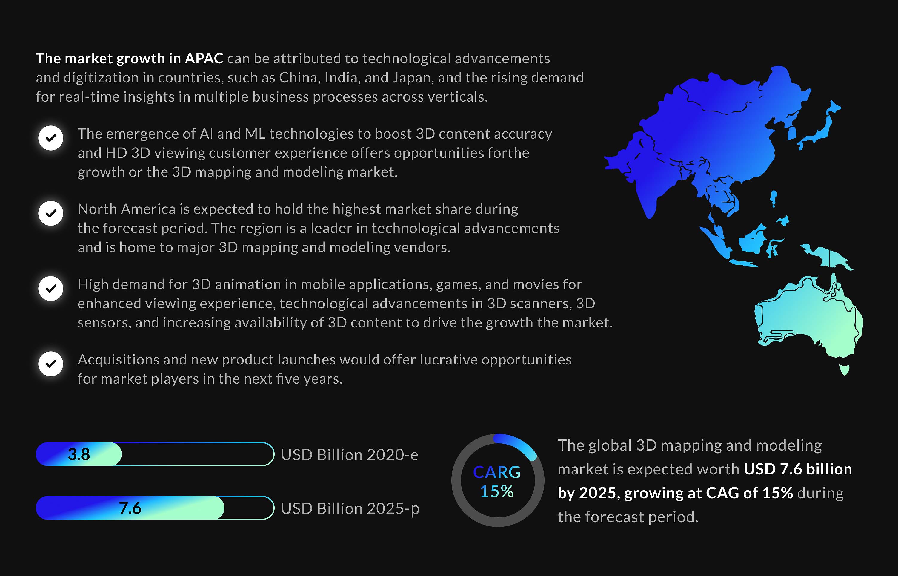
Do you ever wonder what the world would look like if you could see it in 3D? Thanks to 3D mapping technology, we now have the ability to do just that. From creating detailed models of buildings and terrain to mapping entire cities, 3D GIS mapping has transformed the way we understand and interact with our environment. So whether you’re a professional engineer, a hobbyist gamer, or simply someone with a curiosity for exploring the world around you, 3D has something to offer. According to the statistics, the global 3D market is expected to grow from $3.8 billion in 2020 to $7.6 billion by 2025. Al and ML technologies, as well as technological advancements in 3D scanners and sensors, offer huge opportunities in the market.
In this article, we’ll take a deep dive into the world of 3D digital mapping and explore the incredible technology that is helping us see the world in a whole new way. Read on, and you will find out different techniques used for 3D and some of the exciting applications of this technology.
What Is 3D Mapping Technology?
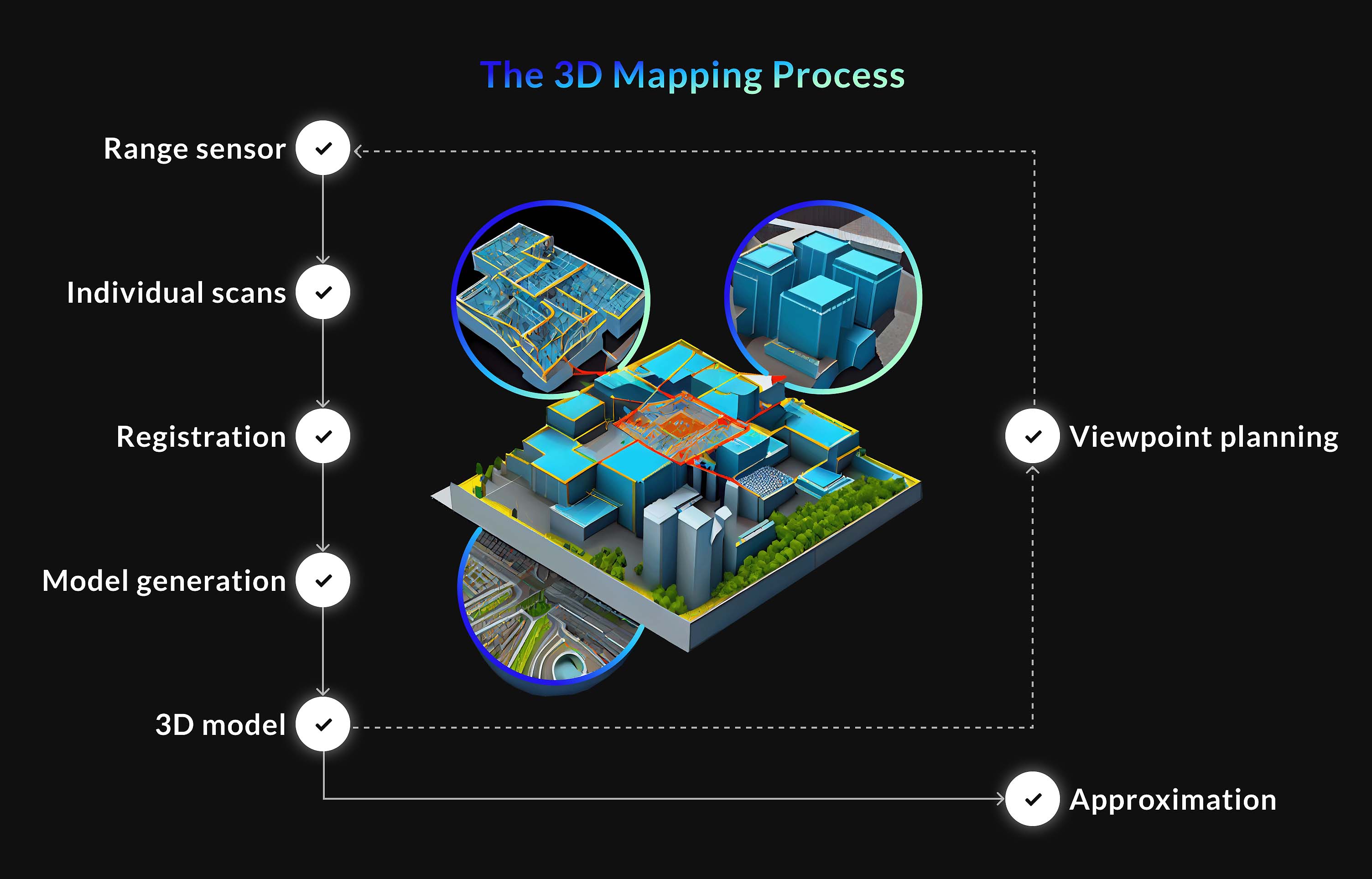
It is a technology used to create 3D representations of objects, surfaces, and environments with the help of spatial mapping. The process involves capturing and processing images and data using various sensors, software, and techniques. The result is an accurate, detailed, and realistic 3D model of the target area that can be used in different industries. These three-dimensional models allow experts to visualize, analyze, and manipulate complex data sets. The general steps of 3D mapping include data acquisition and processing. Then a 3D model of the environment is generated. Once the model is textured, it can be analyzed and visualized using the software. This process may vary depending on the application and the techniques used. You can see an example of the process of 3D digital mapping on the image.
Taken from: ais.informatik.uni-freiburg.de
There are several techniques used for 3D mapping:
Lidar scanning. 3D Lidar mapping is a technique that uses laser beams to measure distances to create a 3D model of the environment. 3D Lidar mapping can be used for urban planning, construction, and other applications requiring accurate and detailed environmental information.
Photogrammetry. Photogrammetry uses photographs taken from different angles to create a 3D model of an object or environment.
Structured light scanning. This technique involves projecting a pattern of light onto an object and analyzing the distortion of the pattern to create a 3D model.
Time-of-flight (TOF) imaging. This technique measures the time it takes for a light pulse to travel from the camera to the object and back to create a 3D model.
Stereo vision. Stereo vision uses two cameras to create a 3D model of an object or environment by comparing the images taken from both cameras.
Simultaneous Localization and Mapping (SLAM). SLAM uses sensors and algorithms to create a 3D map of an environment while simultaneously determining the position of the sensor in that environment.
These techniques can be used individually or in combination with each other, depending on the specific application and the type of 3D map required. They have their strengths and limitations, and the choice of technique will depend on factors such as the desired level of detail and the size and complexity of the object or environment being mapped.
Advantages of 3D Mapping Over 2D Technology
3D mapping services have many advantages over 2D technology. Here we’ll outline the most significant benefits:
Accuracy
3D provides a more accurate representation compared to 2D technology. It captures objects and environments in three dimensions. You will be able to capture detailed information about the shape, size, and spatial relationships of objects. These details can be useful for a wide range of applications.
Visualization
With the help of 3D mapping software, it’s possible to get a more realistic and intuitive representation of the objects and environments. In addition, 3D models enable users to better understand and visualize spatial relationships, thanks to viewing objects from any angle. This can be useful for planning, design, and analysis.
Information
You can get more information from 3D than from 2D technology. 3D models allow users to capture additional data and greater detail. Surface texture, color, and reflectivity are challenging to represent in 2D. Additional information may be used to create realistic visualizations, measure volume, and analyze material properties.
Automation
3D mapping technology is widely used for creating accurate and detailed maps of large areas with minimal human intervention. Besides, 3D maps provide more detailed and sophisticated spatial analysis with the ability to measure distances, angles, and volumes. This can save time and money compared to traditional surveying and mapping methods.
Communication
3D models facilitate the communication process for experts in different industries. It’s easier to share ideas and information with 3D mapping achievements. Such effective collaboration helps boost productivity and achieve greater success.
3D mapping is a versatile technology that has numerous applications in a wide range of fields. It can help build a city, save lives, entertain, navigate, etc. For example, 3Ds max texture mapping allows people to achieve high-quality texture mapping results. It involves assigning 2D images, called textures, to 3D models to give the models more detailed and realistic surface appearances. And 3D laser mapping can be used across various industries, such as urban planning, architecture, civil engineering, mining, construction, archaeology, and cultural heritage. That’s because this technology uses a laser scanner to emit laser pulses that bounce off of objects in the environment and are then detected by the scanner.
Types of 3D Mapping
3D mapping services provide a range of benefits to businesses and individuals. Now let’s take a look at three main types of three-dimensional mapping to know where to apply accurate and detailed 3D maps of the environment.
3D Projection Mapping
3D projection mapping is a special type of 3D that provides an impressive visual experience. It’s also called video mapping, which allows for creative and engaging displays on a wide range of surfaces and objects. 3D projection mapping software can be used in marketing, advertising, entertainment, art, and design. A 3D projector can be a valuable tool for businesses, educators, and artists looking to create engaging and interactive displays. 3D projection mapping projector price depends on several factors, including the brand, model, resolution, and brightness, ranging from a few thousand dollars to tens of thousands of dollars.
3D GIS Mapping
3D mapping services include GIS mapping, which is creating and manipulating 3D digital models of geographic features, landscapes, and objects. It provides a more immersive and realistic representation of the environment with the help of specialized software tools. 3D GIS mapping can be useful for a wide range of industries and applications.
Drone 3D Mapping
3D drone mapping is the process of creating a three-dimensional map of an area or object using drones. A drone is equipped with cameras and other sensors to capture images of the area from multiple angles. 3D drone mapping software is a great solution for land surveying, urban planning, agriculture, mining, and environmental monitoring. DJI 3D mapping is the creation of three-dimensional maps using DJI drones and specialized software.
Applications of 3D GIS Mapping
3D GIS mapping can be used in:
Urban planning;
Environmental management;
Emergency management;
Geology and mining;
Architecture and engineering;
Archaeology and cultural heritage:
Tourism and real estate.
Where Can You Use 3D Mapping?
3D mapping apps and software can be applicable in many industries. We may know mind mapping as a way to organize ideas, but 3D mind mapping software makes it more engaging and effective. Let’s explore more 3D mapping applications.
Disaster Management
In disaster management, 3D mapping solutions can be used to assess the extent of damage, plan relief efforts, and monitor progress. For example, 3D map solutions GmbH can be used to quickly create accurate 3D maps to provide emergency responders with valuable information to aid in relief efforts.
Agriculture
Agriculture 3D mapping is the process of using satellite imagery, aerial photography, and ground-level data to create detailed three-dimensional maps of farmland and crops. 3D projection mapping software can improve yields, reduce costs, and promote sustainable agriculture practices.
Urban
Urban mapping with 3D is the creation of three-dimensional maps of urban areas using Lidar, photogrammetry, and 3D modeling. For instance, Garmin 3D mapping is used by urban planners and architects to create 3D models of buildings and other structures, allowing for more accurate and realistic planning and design.
Healthcare
3D applications for mapping in healthcare are numerous, from diagnosis and treatment planning to medical education and 3D mapping heart. By the way, 3D heart cost can amount to tens of thousands of dollars. One of the most popular uses of mapping in healthcare is EPS RFA 3D mapping to diagnose and treat cardiac arrhythmias.
Energy
Energy 3D mapping involves using data from various sources to provide a detailed view of energy usage patterns and production capabilities in a given area. It can help utilities and energy companies identify areas of high energy consumption, optimize energy production and promote the use of renewable energy sources. By the way, ROS 3D mapping can be used to create 3D maps of natural environments to monitor environmental changes and manage natural resources.
FAQ
How much does 3D projection mapping cost?
The cost of 3D projection mapping varies depending on several factors, such as the project’s complexity, the projection area’s size, the level of detail required, and the event’s location. It can range from a few thousand dollars for a small-scale project to tens of thousands or even hundreds of thousands of dollars for larger, more complex projects. Contact a professional 3D projection mapping company for a more accurate cost estimate.
What are the benefits of 3D mapping?
The key benefits of 3D mapping services include accurate and detailed digital representations of environments, better visualization and analysis of complex spatial data, improved decision-making, cost-effectiveness, increased efficiency, enhanced communication, and more.
What are the different types of 3D data in GIS?
There are two basic types of 3D GIS data: surface and feature data. We should also mention vector 3D data, raster 3D data, and TIN (Triangulated Irregular Network). Each of these 3D data types has its pros and cons, and the choice of which type to use depends on the specific needs of the GIS application.
Best 3D Mapping Solutions from Mappitall
Mappitall is a gis mapping company that transforms data into online mapping solutions to accurately represent spatial relationships. We offer 2D & 3D digital mapping, cartography vectorization, web map development, and indoor mapping. Mappitall provides 3D mapping services to agriculture, real estate, healthcare, sustainable energy, tourism, transportation, and logistics industries. Using our GIS mapping services, you will benefit from the visualization of complex geospatial data, accurate data, improved decision-making, partnership with industry professionals, and more. So don’t wait to address your unique business needs with a data-driven map.
Get in touch with us
Want to discuss your project?
Use our expertise to design your custom mapping software solution.
Just contact us:
Tell us about your project goals, and we’ll get back to you in no time!
An entrepreneur and business leader, Volodymyr began his career in the late 1990s at the Laboratory of Geoinformation Systems of the Kharkiv National University of Radioelectronics.
In 2007 Volodymyr created Mappitall, and grew the company from a small agency providing GIS solutions to one of the industry leaders in Ukraine, a reliable technology partner for many international enterprises and top-level organizations around the world.
As CEO, Volodymyr is the driving force behind the company’s strategy and business development, actively working on the development of Mappitall’s business model, attracting more and more talented people who share his vision and mission.